Approximate Location Map
Large Map »
Latitude: 51.2824 / 51°16'56"N
Longitude: 1.0838 / 1°5'1"E
OS Eastings: 615150
OS Northings: 158213
OS Grid: TR151582
Mapcode National: GBR TY2.JSZ
Mapcode Global: VHLGM.Q1T7
Plus Code: 9F3373JM+XG
Entry Name: 78, Northgate
Listing Date: 7 September 1973
Grade: II
Source: Historic England
Source ID: 1241111
English Heritage Legacy ID: 440030
ID on this website: 101241111
Location: Northgate, Canterbury, Kent, CT1
County: Kent
District: Canterbury
Electoral Ward/Division: Northgate
Parish: Non Civil Parish
Built-Up Area: Canterbury
Traditional County: Kent
Lieutenancy Area (Ceremonial County): Kent
Tagged with: Building
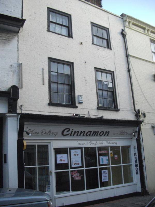
1.
944 NORTHGATE
(South East Side)
No 78
TR 1558 SW 3/594
II GV
2.
C18. 3 storeys painted brick. Parapet with stone coping. 2 sashes set in
wooden architraves. C19 shop front.
Nos 76 to 91 (consec) form a group.
Listing NGR: TR1515158211
External links are from the relevant listing authority and, where applicable, Wikidata. Wikidata IDs may be related buildings as well as this specific building. If you want to add or update a link, you will need to do so by editing the Wikidata entry.


Other nearby listed buildings
