Approximate Location Map
Large Map »
Latitude: 52.7945 / 52°47'40"N
Longitude: -2.3018 / 2°18'6"W
OS Eastings: 379749
OS Northings: 321925
OS Grid: SJ797219
Mapcode National: GBR 05C.T1D
Mapcode Global: WH9CS.M04Z
Plus Code: 9C4VQMVX+R8
Entry Name: Milepost Shropshire Union Canal 0.5 Miles to South of Norbury Junction
Listing Date: 10 January 1972
Grade: II
Source: Historic England
Source ID: 1242904
English Heritage Legacy ID: 443964
ID on this website: 101242904
Location: Norbury Junction, Stafford, Staffordshire, ST20
County: Staffordshire
District: Stafford
Civil Parish: Norbury
Traditional County: Staffordshire
Lieutenancy Area (Ceremonial County): Staffordshire
Church of England Parish: Norbury St Peter
Church of England Diocese: Lichfield
Tagged with: Milestone
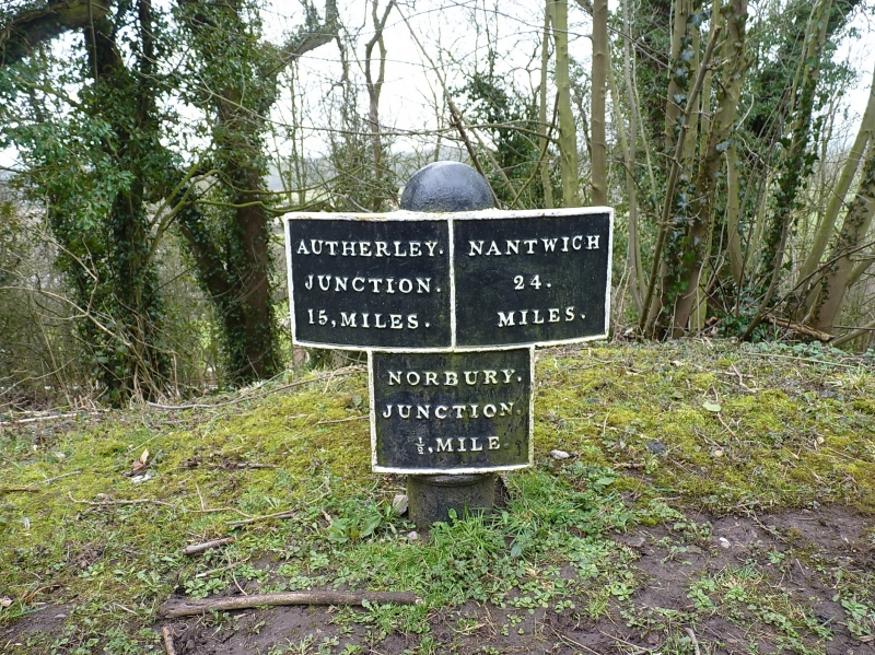
NORBURY
1.
2385
Milepost, Shropshire Union
Canal, ½ mile to south of
Norbury Junction.
SJ 72 SE 7/14
II
2.
Circa 1835. Painted cast-iron. A short post with convex plate and
lower panel giving distances from Autherley, Nantwich and Norbury Junction.
Listing NGR: SJ7974921924
External links are from the relevant listing authority and, where applicable, Wikidata. Wikidata IDs may be related buildings as well as this specific building. If you want to add or update a link, you will need to do so by editing the Wikidata entry.


Other nearby listed buildings
