Approximate Location Map
Large Map »
Latitude: 53.4426 / 53°26'33"N
Longitude: -2.9697 / 2°58'10"W
OS Eastings: 335689
OS Northings: 394417
OS Grid: SJ356944
Mapcode National: GBR 777.LX
Mapcode Global: WH871.CQ3Q
Plus Code: 9C5VC2VJ+24
Entry Name: Arnot St Mary Primary School
Listing Date: 12 April 2001
Grade: II
Source: Historic England
Source ID: 1246239
English Heritage Legacy ID: 487368
ID on this website: 101246239
Location: Walton, Liverpool, Merseyside, L4
County: Liverpool
Electoral Ward/Division: County
Parish: Non Civil Parish
Built-Up Area: Liverpool
Traditional County: Lancashire
Lieutenancy Area (Ceremonial County): Merseyside
Church of England Parish: Walton St Luke
Church of England Diocese: Liverpool
Tagged with: School building
This List entry was subject to a Minor Amendment on 19/01/2018
SJ39SE, 392/4/10158
12-APR-01
ARNOT STREET,
Arnot St Mary Primary School
(Formerly listed as: County Primary School)
GV
II
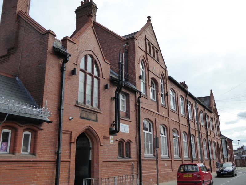
School, formerly Board School. 1883-91, with C20 alterations and extensions. By Edmund Kirby, architect, and constructed by Joshua Henshaw and Sons, builders, both of Liverpool. Built for the Walton -On-The -Hill School Board. Red Ruabon and brown brickwork, with cut and moulded brick, ashlar sandstone and terracotta dressings and detailing, coped gables, tall brick chimneys with corbelled caps and Welsh slate roof coverings.
PLAN: The school has developed on a triangular site between Arnot Street and the cutting for the former London and North-Western Railway. The principal ranges, developed in several closely-spaced phases along almost the full length of Arnot Street, with wings extending northwards enclosing three yard/playground areas.
EXTERIOR: ARNOT STREET ELEVATION: Phase development aligned east west, with long single storeyed link to former school board office at west end of street, and incorporating arched entrance below gablet at east end. To its right, the principal 11-bay range of two and three storeys , arranged 2:2:2:3:2, the central bays 5 and 6 of three storeys, with a hipped roof end carrying twin attic dormers which extend through the eaves. Behind these rises a tall fleche or bell-tower. A west end gable and and east end hipped gable both incorporate canted oriels with mullioned and transomed lights. To either side of the 3-storey bays are tall hipped dormers which extend through the eaves, a pair to the west and three separate windows to the east. 2 and 3-light windows to all levels of mullion and transom form, with moulded brick strings to heads and cills. Further east, a short single-storey link leads to a single storey, triple gabled central range of 1891,each gable with a wide 7-light transomed window beneath a shallow pointed arch, each light with a segmental- arched head. Terracotta hood moulds to arches, and above, raised diaper work to gable apexes, and to upper parts of walling between gables. A further low linking range connects with the main entrance contained within a 2-storey range, formerly the headmasters office, of two bays, with a gablet to the left, incorporating a 3-light transomed window above a shallow pointed- doorway with a planked door. To the right, a 2-storeyed, 11-bay east range with wide gables to each end, and shallow pilasters defining the bays. Shallow segmental arched window openings throughout, with stone cills on moulded brick strings, and with moulded brick storey band. Tall pointed arch to entrance at east end. Gable apexes with blind triple lights.
REAR ELEVATIONS: West range with long 3 and 2-storeyed L-shaped wing extending north and then east, from 3-storeyed section of frontage range. To east, hipped end to west range adjoins rear of triple-gabled centre range, the rear pile with ridge running east-west, and with central gable with twin 3-light arch-headed windows to north elevation. Further east, entrance below headmasters office gives access to covered area below metal beam supporting upper floor. Staircase to east of entrance supported on ornamental cast-iron brackets leads to first floor covered gallery connecting frontage range to double pile rear range extending northward almost to rear site boundary. This is 2-storeyed, with wide central gable and flanking gabled dormers to west side and triple gabled centre to east elevation with hipped roofs to end bays. Rear of east frontage range carries first floor gallery on western half and returns northwards at the east end, linking with open fronted shelters which define the eastern boundary of the school site.
INTERIORS: Interior spaces throughout the school have been incrementally altered, but much original fabric remains as evidence of original functions of different parts of the complex, including staircases, hearths and ceiling beams to carry moveable partitions by means of which classrooms could be sub-divided or enlarged according to need.
HISTORY: The complex of buildings at Arnot Street is one of the largest surviving examples of Board school provision in Liverpool. The original plans for the site show separate provision for boys and girls, and what appears to be a creche facility adjacent to a sewing classroom and cloakroom for girl pupils. The school appears to have been the principal site of the Walton Board, being also the location of the Board's office building at the west end of Arnott Street.
Forms a group with Rainbow House, formerly the Walton-On-The-Hill School Board Office (item 4/10158).
An architecturally distinguished and spatially complex Board School developed between 1883 and 1891. Designed by one of Liverpool's most important C19 architects, and one of the largest surviving Board Schools in the city, the Arnot Street School demonstrates the very high quality of the school buildings provided for Liverpool's rapidly-expanding population in the late C19.
Listing NGR: SJ356894417
External links are from the relevant listing authority and, where applicable, Wikidata. Wikidata IDs may be related buildings as well as this specific building. If you want to add or update a link, you will need to do so by editing the Wikidata entry.


Other nearby listed buildings
