Approximate Location Map
Large Map »
Latitude: 53.4756 / 53°28'32"N
Longitude: -2.2579 / 2°15'28"W
OS Eastings: 382980
OS Northings: 397679
OS Grid: SJ829976
Mapcode National: GBR DFK.S3
Mapcode Global: WHB9G.9W2Y
Plus Code: 9C5VFPGR+6R
Entry Name: The Giants Basin
Listing Date: 6 June 1994
Grade: II
Source: Historic England
Source ID: 1247068
English Heritage Legacy ID: 456065
ID on this website: 101247068
Location: Ordsall, Manchester, Greater Manchester, M3
County: Manchester
Electoral Ward/Division: City Centre
Parish: Non Civil Parish
Built-Up Area: Manchester
Traditional County: Lancashire
Lieutenancy Area (Ceremonial County): Greater Manchester
Church of England Parish: Hulme The Ascension
Church of England Diocese: Manchester
Tagged with: Weir
MANCHESTER
SJ8297 POTATO WHARF
698-1/18/319 (East side)
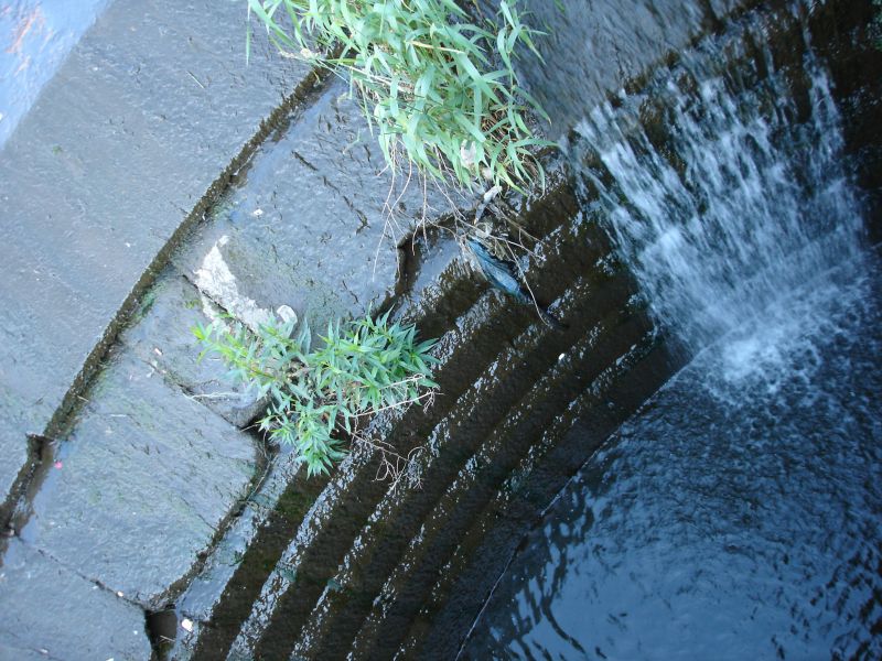
The Giant's Basin
GV II
Circular weir. Probably 1765, by James Brindley, for Duke of
Bridgewater, altered in C19. Coursed squared sandstone.
Circular structure approx.10m in diameter, with 2-course
sloped lip. Part of hydraulic system by which the Bridgewater
Canal terminus basin exploited the course of the River
Medlock, which was diverted through a culvert running from
east of Deansgate at Knott Mill to Potato Wharf, and the canal
overflow was returned to the river via this weir. Simple
stucture of national historical importance. Forms group with
canal basin at Potato Wharf (q.v.), and with Castelfield
Railway Viaduct (q.v.), and Culvert arches, New Elm Road
(q.v.); associated with Floodgate, Deansgate (q.v.).
Listing NGR: SJ8298097679
External links are from the relevant listing authority and, where applicable, Wikidata. Wikidata IDs may be related buildings as well as this specific building. If you want to add or update a link, you will need to do so by editing the Wikidata entry.


Other nearby listed buildings
