Approximate Location Map
Large Map »
Latitude: 53.872 / 53°52'19"N
Longitude: -1.7488 / 1°44'55"W
OS Eastings: 416615
OS Northings: 441784
OS Grid: SE166417
Mapcode National: GBR JR7N.6R
Mapcode Global: WHC8X.3YJ1
Plus Code: 9C5WV7C2+RF
Entry Name: Hall Croft
Listing Date: 7 April 1988
Grade: II
Source: Historic England
Source ID: 1252590
English Heritage Legacy ID: 433671
ID on this website: 101252590
Location: Hawksworth, Leeds, West Yorkshire, LS20
County: Leeds
Electoral Ward/Division: Guiseley and Rawdon
Parish: Non Civil Parish
Built-Up Area: Hawksworth
Traditional County: Yorkshire
Lieutenancy Area (Ceremonial County): West Yorkshire
Church of England Parish: Guiseley St Oswald King and Martyr
Church of England Diocese: Leeds
Tagged with: Building
AIREBOROUGH MAIN STREET
SE 14 SE
LS 20 (north side)
Hawksworth
4/61 Hall Croft
-
GV II
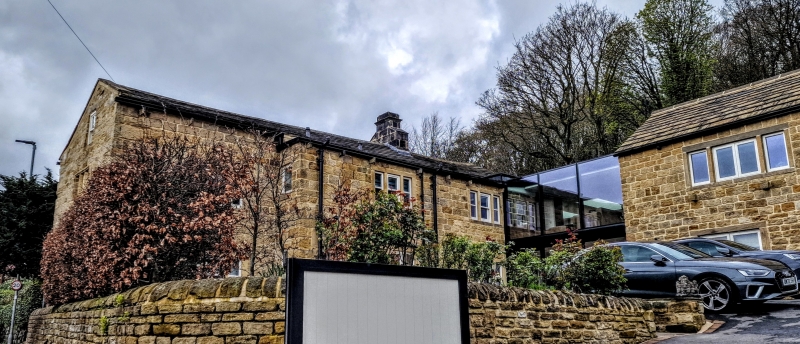
Farmhouse, now house. Probably earlier C17, partly rebuilt and enlarged in
C18; altered. Coursed squared sandstone with quoins, stone slate roof.
Gable to road. Three units, the first (next to road) single depth, the
others double depth, breaking forwards. Two and a half and two storeys under
one roof; doorway with plain surround next to left corner of C18 portion;
left of this the earlier portion, set back, is of larger masonry up to
1st floor window head level (probably raised above this), and has a recessed-
chamfered 3-light mullioned window at 1st floor, and in the-gable wall a
similar window at the same level (lacking mullions); otherwise 3-light flat-
faced flush mullion windows of C18 type, and a tall attic window in the
gable. One ridge chimney, and at the rear of the 1st unit a large extruded
chimney stack of segmental section, finished with a rectangular chimney with
offset and moulded cap. Interior not accessible at time of survey, but
likely to contain features of interest in the earlier portion. (Attached at
the right-hand end, at right angles, a wing in matching style, but probably
a C20 conversion of former agricultural building, not included in the item).
Interior: South end of main (west) range contains remains of earlier timber
framed building, incorporated in rear wall, including at least one wall post
with mortices and peg holes for former angle-bracing to former tie-beam, and
to scarf jointed wallplate (which has peg holes indicating positions of
former wallposts); also in this wall, a large rectangular fireplace with
massive rectangular lintel, and a similar but smaller fireplace in the
chamber above; lime-ash floor to former attic granary at this end; 3 lateral
chamfered beams, including one in south gable wall, with chamfer-stops, and
stop-chamfered floor joists; at north end of east wall, a Tudor-arched
doorway with broad stop-chamfered surround; and flight of stone steps around
north east corner leading to blocked doorway in north gable wall (all these
now covered by later addition). North range, formerly detailed cow-house,
has integral half-sunk dairy on caring room, with former external doorway and
windows now covered by later addition).
Listing NGR: SE1661541784
External links are from the relevant listing authority and, where applicable, Wikidata. Wikidata IDs may be related buildings as well as this specific building. If you want to add or update a link, you will need to do so by editing the Wikidata entry.


Other nearby listed buildings
