Approximate Location Map
Large Map »
Latitude: 52.96 / 52°57'35"N
Longitude: -1.1611 / 1°9'39"W
OS Eastings: 456449
OS Northings: 340618
OS Grid: SK564406
Mapcode National: GBR LLM.Q2
Mapcode Global: WHDGS.4VCP
Plus Code: 9C4WXR5Q+XH
Entry Name: Churchyard Wall, Gateways and Railings at Church of All Saints
Listing Date: 17 October 1974
Last Amended: 30 November 1995
Grade: II
Source: Historic England
Source ID: 1254983
English Heritage Legacy ID: 458517
ID on this website: 101254983
Location: All Saints' Church, Nottingham, Nottinghamshire, NG7
County: City of Nottingham
Electoral Ward/Division: Arboretum
Parish: Non Civil Parish
Built-Up Area: Nottingham
Traditional County: Nottinghamshire
Lieutenancy Area (Ceremonial County): Nottinghamshire
Church of England Parish: Nottingham St Peter with St James
Church of England Diocese: Southwell and Nottingham
Tagged with: Churchyard wall
NOTTINGHAM
SK54SE RALEIGH STREET
646-1/4/516 (North West side)
17/10/74 Churchyard wall, gateways and
railings at Church of All Saints
(Formerly Listed as:
RALEIGH STREET
All Saint's Churchyard Wall, Gate
Piers, Gate archway, Gates &
Railings)
GV II
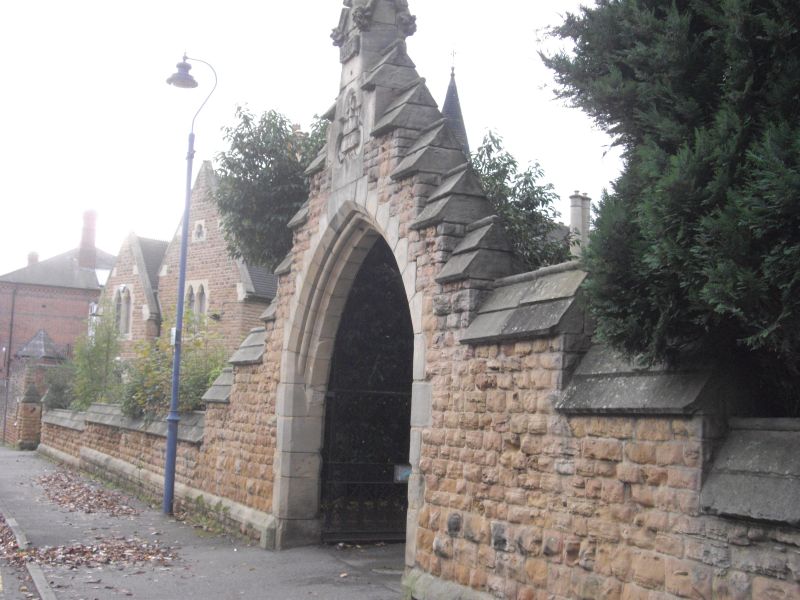
Churchyard wall, gateways and railings. 1864-65. By Hine &
Evans of Nottingham for William Windley. Rockfaced Bulwell
stone with ashlar plinth and moulded coping. The wall runs
north eastwards from 75 Raleigh Street approx 100m to a
rounded corner, then runs westwards approx 80m along All
Saints Street as far as All Saints Terrace.
Raleigh Street section has a central pointed arched gateway
under a crowstepped gable and finial, with original
wrought-iron gates. To its left, a gateway with square piers
and pyramidal caps, and a similar pair of gates.
All Saints Street section has a gateway to the church's north
porch, with cast-iron sliding gates and flanking railings.
Pair of square piers at the corner with Tennyson Street.
(The Buildings of England: Pevsner N: Nottinghamshire: London:
1979-: 237).
Listing NGR: SK5644940618
External links are from the relevant listing authority and, where applicable, Wikidata. Wikidata IDs may be related buildings as well as this specific building. If you want to add or update a link, you will need to do so by editing the Wikidata entry.


Other nearby listed buildings
