Approximate Location Map
Large Map »
Latitude: 53.9613 / 53°57'40"N
Longitude: -1.0831 / 1°4'59"W
OS Eastings: 460254
OS Northings: 452078
OS Grid: SE602520
Mapcode National: GBR NQWM.9Q
Mapcode Global: WHFC3.BPGK
Plus Code: 9C5WXW68+GP
Entry Name: The Norman House
Listing Date: 14 June 1954
Last Amended: 14 March 1997
Grade: I
Source: Historic England
Source ID: 1256494
English Heritage Legacy ID: 464845
Also known as: Medieval stone town house known as The Norman House to the rear of Nos 48 and 50 Stonegate
ID on this website: 101256494
Location: York, North Yorkshire, YO1
County: York
Electoral Ward/Division: Guildhall
Parish: Non Civil Parish
Built-Up Area: York
Traditional County: Yorkshire
Lieutenancy Area (Ceremonial County): North Yorkshire
Church of England Parish: York St Michael-le-Belfrey
Church of England Diocese: York
Tagged with: Building Hall house Archaeological site
YORK
SE6052SW STONEGATE
1112-1/27/1046 (North West side)
14/06/54 The Norman House
(Formerly Listed as:
STONEGATE
Remains of Norman House in Church
Passage off Stonegate)
GV I
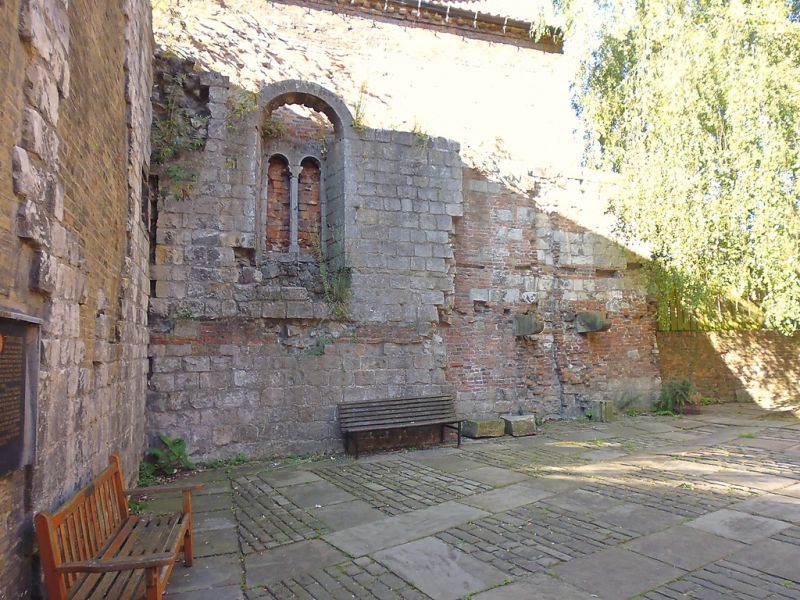
Walls embedded in rear walls of Nos 46, 48 and 50 (qqv)
comprising remains of hall-house with undercroft. Late C12.
Tooled magnesian limestone. Wall approximately 11 metres long,
attached to rear of No.46, retains first floor window of 2
round-arched lights beneath semicircular rere-arch with
central shaft having moulded base and waterleaf capital:
window rebated for shutter for which one hinge survives and
socket for locking bar. Wall approximately 6 metres long,
attached to rear of Nos 48 and 50, incorporates on first floor
rebated cupboard recess, grooved for shelves, with timber
lintel. Excavations in 1939 uncovered the foundations of three
central piers, now below ground, which originally supported
the undercroft roof.
Scheduled Ancient Monument.
(City of York: RCHME: The Central Area: HMSO: 1981-: 225).
Listing NGR: SE6025452078
External links are from the relevant listing authority and, where applicable, Wikidata. Wikidata IDs may be related buildings as well as this specific building. If you want to add or update a link, you will need to do so by editing the Wikidata entry.


Other nearby listed buildings
