Approximate Location Map
Large Map »
Latitude: 53.9541 / 53°57'14"N
Longitude: -1.0813 / 1°4'52"W
OS Eastings: 460384
OS Northings: 451285
OS Grid: SE603512
Mapcode National: GBR NQWQ.P9
Mapcode Global: WHFC3.CWB1
Plus Code: 9C5WXW39+MF
Entry Name: Skeldergate Bridge and Attached Tollhouse, Abutment Walls and Steps
Listing Date: 1 July 1968
Last Amended: 14 March 1997
Grade: II
Source: Historic England
Source ID: 1256602
English Heritage Legacy ID: 464723
ID on this website: 101256602
Location: Clementhorpe, York, North Yorkshire, YO23
County: York
Electoral Ward/Division: Guildhall
Parish: Non Civil Parish
Built-Up Area: York
Traditional County: Yorkshire
Lieutenancy Area (Ceremonial County): North Yorkshire
Church of England Parish: York All Saints, Pavement
Church of England Diocese: York
Tagged with: Bridge Road bridge
SE6051SW
1112-1/21/11
01/07/68
YORK
SKELDERGATE
Skeldergate Bridge and attached tollhouse, abutment walls and steps
(Formerly Listed as: Skeldergate Bridge)
GV
II
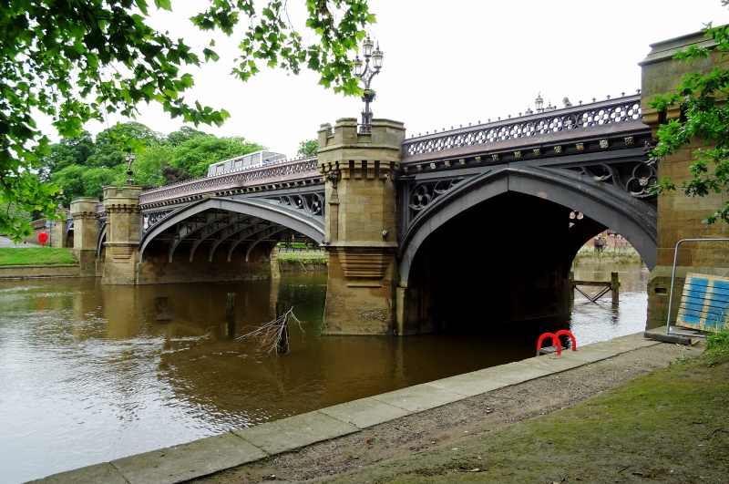
Bridge, tollhouse, steps, and abutment walls extended to
enclose St George's Field park and carpark, and Skeldergate
park. 1879-1881, reconstructed and strengthened 1938-39. By
Thomas and George Page.
MATERIALS: bridge of steel and cast-iron girders on ashlar
piers, and cast-iron parapet; ashlar tollhouse, with hipped
slate roof and embattled tower with paired octagonal stacks
with moulded cornices; abutment walls and steps of ashlar.
EXTERIOR: bridge has 3 river spans between single pedestrian
arches. 4-centred arches, the centre one flattened, with
traceried spandrels, those to centre arch incorporating the
City arms of York and the Keys of St Peter. Piers are treated
as machicolated turrets, those flanking centre arch
castellated. Parapet pierced by quatrefoils over band of
heraldic badges. Piers form half-octagonal embrasures in
parapet and enclose octagonal pedestals on chamfered plinth,
surmounted by gas lamp standards of 5 octagonal shafts linked
by tracery, the outer ones with ogee caps and crocket finials;
interspersed with crocketed gablets. Centre shaft cast in
blind trellis work incorporating the York rose. Traceried head
supports three tapered lanterns with pennant finials,
encircled by coronets. Tracery incorporates the City arms.
Tollhouse: 2 storeys on basement plinth, with 3-stage
octagonal tower, and 2-stage projecting staircase tower.
Segment-arched doorway, approached by external steps, and slit
lights in staircase tower. Elsewhere, windows are mullioned
and transomed, of 1-, 2- or 3-lights, with traceried heads and
square-latticed glazing. Panelled door to tollbooth at bridge
level, beneath half-hipped canopy on carved brackets. Mullions
and window and door surrounds are hollow chamfered.
On north-east bank, downstream abutment contains blocked
round-arched doorway to room which formerly housed machinery
for opening the adjacent river span of bridge.
A panel to left of tollbooth door reads:
" This bridge was formally declared free/ from tolls on April
1st 1914 by/ The Right Hon Henry Rhodes Brown Lord Mayor/
Robert Newbald Kay Esquire./ Sheriff Alderman Norman Green
(Chairman of Bridge Committee )"
Abutment walls have moulded coping. Piers form pedestals to
tapering octagonal gas lamp standards on stepped bases;
tapered lanterns, encircled by coronets, have pennant finials.
Foundation stone set in upstream parapet reads:
"The Foundation Stone/ of this Bridge was laid 12th June 1878
by/ The Right Honourable William Lord Mayor John Bellerby
Esquire, Sheriff./ George Gordon Page Esquire, Engineer".
Second stone in downstream parapet reads:
"This Bridge/ was first used by Foot Passengers on the 1st
January 1881, and was formally/ Opened for General Traffic on
the 10th March 1881,/ by the Right Honourable John Stephenson
Rowntree, Lord Mayor/ Richard Thompson Esquire, Sheriff".
INTERIOR: tollhouse not inspected.
Listing NGR: SE6038451285
External links are from the relevant listing authority and, where applicable, Wikidata. Wikidata IDs may be related buildings as well as this specific building. If you want to add or update a link, you will need to do so by editing the Wikidata entry.


Other nearby listed buildings
