Approximate Location Map
Large Map »
Latitude: 53.9638 / 53°57'49"N
Longitude: -1.076 / 1°4'33"W
OS Eastings: 460721
OS Northings: 452365
OS Grid: SE607523
Mapcode National: GBR NQXL.VT
Mapcode Global: WHFC3.FMWM
Plus Code: 9C5WXW7F+GJ
Entry Name: Monkgate House
Listing Date: 14 June 1954
Grade: II
Source: Historic England
Source ID: 1257217
English Heritage Legacy ID: 464131
Also known as: 44 Monkgate
George Hudson House
ID on this website: 101257217
Location: The Groves, York, North Yorkshire, YO31
County: York
Electoral Ward/Division: Guildhall
Parish: Non Civil Parish
Built-Up Area: York
Traditional County: Yorkshire
Lieutenancy Area (Ceremonial County): North Yorkshire
Church of England Parish: York St Michael-le-Belfrey
Church of England Diocese: York
Tagged with: House
YORK
SE6052SE MONKGATE
1112-1/14/739 (South East side)
14/06/54 No.44
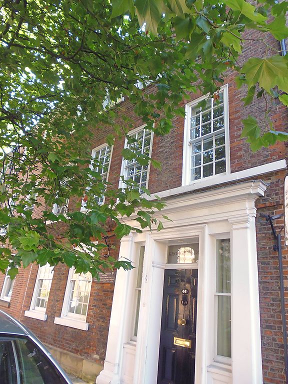
Monkgate House
GV II
House, now offices. Built shortly after 1723; altered 1827 and
c1835. Alterations of 1827 for George Hudson. Brick in Flemish
bond with painted stone and stucco dressings. Pantiled roof.
EXTERIOR: 3 storeys plus attic. 4 bays. Facade has stone
plinth, painted stone 1st floor sill band with a brick band
below, and a timber cornice gutter. The windows are glazing
bar sashes with rubbed brick flat arches. The attic dormer has
a pitched roof and 6-pane sash. On the ground floor a doorway
of early C19 date occupies the 2 right-hand bays. It has a
painted stone or stucco surround with Tuscan pilasters and a
cornice. The door has an architrave and flanking lights and
has 6 panels and an overlight. Ridge chimney at left.
INTERIOR: open well staircase with cast-iron balustrade of
geometric panels and serpentine handrail.
A plaque records that George Hudson MP 1800-1871 lived here.
(An Inventory of the Historical Monuments of the City of York:
RCHME: Outside the City Walls East of the Ouse: HMSO: 1975-:
90).
Listing NGR: SE6072152361
External links are from the relevant listing authority and, where applicable, Wikidata. Wikidata IDs may be related buildings as well as this specific building. If you want to add or update a link, you will need to do so by editing the Wikidata entry.


Other nearby listed buildings
