Approximate Location Map
Large Map »
Latitude: 52.1839 / 52°11'2"N
Longitude: -2.1532 / 2°9'11"W
OS Eastings: 389623
OS Northings: 253974
OS Grid: SO896539
Mapcode National: GBR 1GF.2FG
Mapcode Global: VH92V.MCKN
Plus Code: 9C4V5RMW+HP
Entry Name: Home Farmhouse
Listing Date: 3 August 1972
Grade: II
Source: Historic England
Source ID: 1258268
English Heritage Legacy ID: 444699
ID on this website: 101258268
Location: Spetchley, Wychavon, Worcestershire, WR5
County: Worcestershire
District: Wychavon
Civil Parish: Spetchley
Traditional County: Worcestershire
Lieutenancy Area (Ceremonial County): Worcestershire
Church of England Parish: White Ladies Aston with Churchill and Spetchley
Church of England Diocese: Worcester
Tagged with: Farmhouse
SPETCHLEY SPETCHLEY
1.
2301
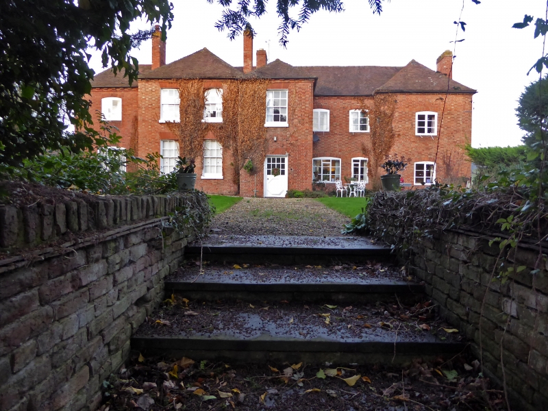
Home Farmhouse
SO 85 SE 4/766
II
2.
Early C18. Red brick. 2-storeys. Irregular front with projections. 12-pane
sashes and casements. Hipped tile roof. Brick dentil eaves. Wing at rear.
Listing NGR: SO8962353974
External links are from the relevant listing authority and, where applicable, Wikidata. Wikidata IDs may be related buildings as well as this specific building. If you want to add or update a link, you will need to do so by editing the Wikidata entry.


Other nearby listed buildings
