Approximate Location Map
Large Map »
Latitude: 54.2862 / 54°17'10"N
Longitude: -0.3914 / 0°23'28"W
OS Eastings: 504816
OS Northings: 489035
OS Grid: TA048890
Mapcode National: GBR TLQW.28
Mapcode Global: WHGC0.YJTG
Plus Code: 9C6X7JP5+FF
Entry Name: Wall on South Side of Paradise at East End
Listing Date: 8 June 1973
Grade: II
Source: Historic England
Source ID: 1258863
English Heritage Legacy ID: 445753
ID on this website: 101258863
Location: Scarborough, North Yorkshire, YO11
County: North Yorkshire
District: Scarborough
Electoral Ward/Division: Castle
Parish: Non Civil Parish
Built-Up Area: Scarborough
Traditional County: Yorkshire
Lieutenancy Area (Ceremonial County): North Yorkshire
Church of England Parish: Scarborough St Mary
Church of England Diocese: York
Tagged with: Wall
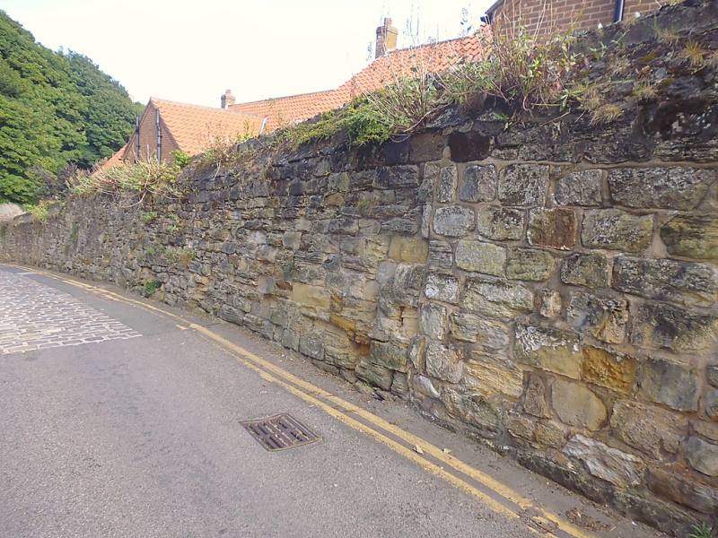
1. PARADISE
1605
Wall on south side of
Paradise at east end
TA 0489 2/296
II
2.
Old stone rubble wall with battered coping, rendered top, similar to churchyard
walls and returned for short section to Castlegate.
Listing NGR: TA0479089033
External links are from the relevant listing authority and, where applicable, Wikidata. Wikidata IDs may be related buildings as well as this specific building. If you want to add or update a link, you will need to do so by editing the Wikidata entry.


Other nearby listed buildings
