Approximate Location Map
Large Map »
Latitude: 53.9639 / 53°57'50"N
Longitude: -1.0866 / 1°5'11"W
OS Eastings: 460024
OS Northings: 452368
OS Grid: SE600523
Mapcode National: GBR NQVL.KS
Mapcode Global: WHFC3.8MTK
Plus Code: 9C5WXW77+H9
Entry Name: Wandesford House
Listing Date: 14 June 1954
Grade: II*
Source: Historic England
Source ID: 1259452
English Heritage Legacy ID: 462871
ID on this website: 101259452
Location: York, North Yorkshire, YO30
County: York
Electoral Ward/Division: Guildhall
Parish: Non Civil Parish
Built-Up Area: York
Traditional County: Yorkshire
Lieutenancy Area (Ceremonial County): North Yorkshire
Church of England Parish: York St Olave with St Giles
Church of England Diocese: York
Tagged with: House
YORK
SE6052SW BOOTHAM
1112-1/13/72 (North East side)
14/06/54 No.37
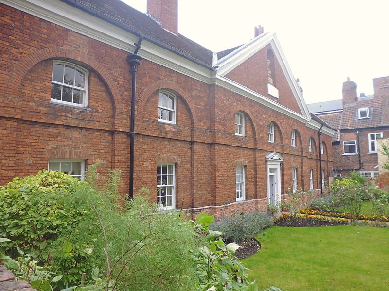
Wandesford House
GV II*
Formerly known as: No.37 The Wandesford Hospital BOOTHAM.
Almshouses. Opened in 1743 as the Mary Wandesford Old Maid's
Hospital; altered mid C19, and in 1968 when the present
doorcase was added. Brick in Flemish bond with plain tile
roof.
EXTERIOR: symmetrical, of 2 storeys and 7 bays, with the 3
central bays projecting under a pediment. Each bay has a
round-arched recess within which the windows of both storeys
are set, and a deep impost band is carried from arch to arch
across the recesses. The windows are glazing bar sashes, the
ground-floor ones with flat rubbed brick arches and the 1st
floor ones with segmental heads and 3 over 3 panes. The
doorway has a timber architrave and a broken pediment. The
cornice gutter is heavily moulded. Within the pediment there
is a niche containing a bust of the foundress. To the right of
the 1st and 6th bays there are lead rainwater hoppers and
downpipes. Chimneys to left and right, and on ridge to each
side of the 3 central bays.
INTERIOR: not inspected. RCHM record 2 original staircases,
each single flight with closed string, square newels and
turned oak balusters with moulded and ramped handrail.
(An Inventory of the Historical Monuments in the City of York:
RCHME: Outside the City Walls East of the Ouse: HMSO London:
1975-: 51).
Listing NGR: SE6002452368
External links are from the relevant listing authority and, where applicable, Wikidata. Wikidata IDs may be related buildings as well as this specific building. If you want to add or update a link, you will need to do so by editing the Wikidata entry.


Other nearby listed buildings
