Approximate Location Map
Large Map »
Latitude: 51.5094 / 51°30'33"N
Longitude: -0.0515 / 0°3'5"W
OS Eastings: 535317
OS Northings: 180738
OS Grid: TQ353807
Mapcode National: GBR J9.PP0
Mapcode Global: VHGR1.2B48
Plus Code: 9C3XGW5X+QC
Entry Name: St Pauls Terrace
Listing Date: 1 July 1983
Grade: II
Source: Historic England
Source ID: 1260100
English Heritage Legacy ID: 441681
ID on this website: 101260100
Location: Shadwell, Tower Hamlets, London, E1W
County: London
District: Tower Hamlets
Electoral Ward/Division: St Katharine's & Wapping
Parish: Non Civil Parish
Built-Up Area: Tower Hamlets
Traditional County: Middlesex
Lieutenancy Area (Ceremonial County): Greater London
Church of England Parish: St Paul Shadwell
Church of England Diocese: London
Tagged with: Building
THE HIGHWAY E1
1.
4431 No 1 to 3 consec
(St Paul's Terrace)
TQ 3580 23/2
II GV
2.
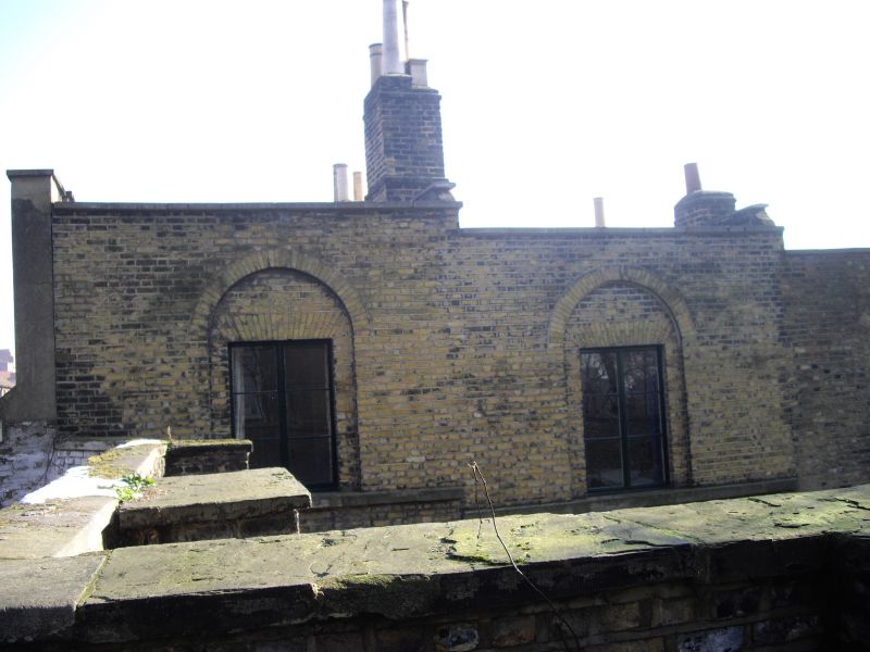
C1820 small stepped terrace of 2 storey one bay houses built of stock brick, giving
onto a courtyard below east retaining wall of St Paul's Shadwell churchyard. Stepped
plinths and first floor stone sill bands; plain stepped parapet copings. Ground
floor windows 2 light wood casement each of 3 horizontal panes with thin glazing bars,
flat gauged brick arches. First floor windows similar but slightly narrower and
contained in semi-circular arched panels. Doorway are set in arched openings,
pilastered reveals, moulded doorheads and plain fanlights. Doors of 4 moulded panels.
Stone flagged path in front. A good example of a small scale early C19 artisan's
dwelling. Of some architectural merit with its arcading and gauged brick window heads,
the terrace's value is further increased by its immediate proximity to the listed
St Paul's Church. It also has particular sociological interest, being situated on
the Highway, formerly the Ratcliff Highway, which during the century became one of
the most notoriously dangerous overcrowded and criminal areas in London.
Listing NGR: TQ3531780738
External links are from the relevant listing authority and, where applicable, Wikidata. Wikidata IDs may be related buildings as well as this specific building. If you want to add or update a link, you will need to do so by editing the Wikidata entry.


Other nearby listed buildings
