Approximate Location Map
Large Map »
Latitude: 54.6489 / 54°38'56"N
Longitude: -2.5991 / 2°35'56"W
OS Eastings: 361437
OS Northings: 528363
OS Grid: NY614283
Mapcode National: GBR BG9P.38
Mapcode Global: WH92K.1DLY
Plus Code: 9C6VJCX2+H9
Entry Name: Acorn Bank Mill with associated weir
Listing Date: 12 April 1984
Last Amended: 11 July 2018
Grade: II*
Source: Historic England
Source ID: 1265726
English Heritage Legacy ID: 423397
Also known as: Acorn Bank Mill To North West Of Acorn Bank House
ID on this website: 101265726
Location: Westmorland and Furness, Cumbria, CA10
County: Cumbria
District: Eden
Civil Parish: Temple Sowerby
Built-Up Area: Temple Sowerby
Traditional County: Westmorland
Lieutenancy Area (Ceremonial County): Cumbria
Church of England Parish: Temple Sowerby St James
Church of England Diocese: Carlisle
Tagged with: Historic house
Water mill with associated features, primary for corn, possibly of medieval origins, the current buildings dating to the late C18 or early C19, and retain mid-C19 machinery. In the care of the National Trust, with extensive restoration from 1989 onwards.
Watermill for corn, late C18 or early C19 with later alterations, reconstructed from 1989 onwards.
MATERIALS: squared local Permian sandstone, mainly laid to courses, later sections being snecked, gables being quioned. Westmoreland slate roofs laid to diminishing courses to a stone ridge.
PLAN: a two storey linear range with the mill to the centre, kiln and granary upslope to the east and a cart shed/saw mill to the west. The granary is accessed at first floor level via the gable end, with access through to the drying floor of the kiln, then on to the first floor of the mill and through to the store above the cart shed. The wheelpit, within a wheelhouse, is on the north side of the mill, fed from the east, the headrace running from a weir approximately 350m to the east-south-east. On the south side is a yard which provides ground floor access to the store below the granary, a passageway through the range from which the kiln was stoked, the mill and the cart shed. Within the mill there is a staircase to the first floor via a mezzanine floor formed by the hurst frame upon which the millstones are set.
EXTERIOR: the mill is of three bays, its roof line being continuous with the later, single bay cartshed. The kiln and granary is of four bays with a slightly higher roof line, the kiln being marked externally by two simple ridge vents. The roof has plain verges. Window and door joinery is traditionally detailed, but a product of restoration since 1989.
South elevation: the granary retains the scar line of a former building that extended to the bank barn to the south. The doorway to the ground floor store is quoined, that to the kiln, immediately adjacent, appears to be inserted and has well-dressed monolithic jambs. The doorway to the mill also has monolithic jambs and appears to have been reduced in size from a former quoined doorway, the opening now being partly preserved with a window. To the left there is a further window, with a window above lighting the first floor, both being framed with monolithic jambs, lintels and sills. The single windows to both the first floor of the kiln and cartshed are similarly treated, whereas the loading door to the first floor of the mill is not stone framed. The entrance to the cart shed is segmentally arched.
North elevation: the doorway to the kiln passage is quoined, whereas the window to the first floor has monolithic jambs. The single windows to the granary and store below, and that to the store above the cart shed are all unframed. In addition to the openings for the wheel axles, there are two openings between the mill and the wheelhouse, these being shuttered, one having a quoined surround, the other being timber-framed. The doorway to the rear of the cartshed has a timber lintel and appears to have been reduced in size.
The wheelhouse extends the length of the mill, and is open to the west. It has a lean-to roof extending from immediately below the mill roof. Its walling is of snecked stonework to eaves level, the east end being timber boarded above, with an opening for the launder which is of timber, approaching from the east, and supported on rubble stone piers. In the northern wall of the wheelhouse there is a wall box and a sleeved iron bar, both interpreted as being related to the reuse of the second waterwheel position for the gypsum mine in the 1920s.
East gable: this is built into the rising ground, the single opening being the doorway to the first floor granary.
West gable: this has a single opening: a centrally placed window to the ground floor. Set into the wall, just above to the north of the window there is a bearing box.
INTERIOR: roof and floor structures are traditionally detailed and built, but are post-1989 reconstructions. Historic timbers are restricted to parts of the hurst frame within the mill and include a substantial bressummer beam formed from three scarf-jointed timbers: this retains various notches and empty mortises that relate to previous arrangements of milling machinery. Also marking earlier machinery within the mill is a former bearing box and at least two other bearing positions built into the walls. The 1823 date stone is set into the lower part of the west wall. On the first floor above there are the remains of a fireplace that has been cut through to form the doorway to the store above the cart shed.
The kiln is a 2016 reconstruction that incorporates some original stone and iron work, including some of the perforated cast iron tiles which formed the drying floor.
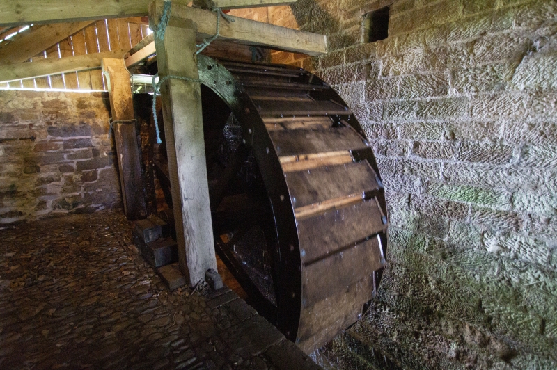
MACHINERY: this is described in the building survey produced in 2010 and has been undergoing restoration using traditional methods since the 1990s. Most of the gearing is of cast iron, although the machinery incorporates a lot of timberwork, much of it restored. There are two waterwheels, these being iron rimmed, timber spoked, centre-drive wheels approximately 3.66m (12ft) diameter and 1.1m (3ft 6in) wide with timber buckets. The upstream wheel being a pitchback wheel driving two sets of millstones (one set being French burr stones) and an ancillary drive via a spur wheel. The second wheel was undergoing restoration in 2017. It is of a slightly more complex design originally incorporating a secondary rim drive and is thought to have been operated as an overshot wheel, also driving two pairs of millstones and a further ancillary drive. Much less of the machinery for the second wheel survives. The sack hoist and jigger, both formerly driven via ancillary drives from the second wheel, are reconstructions.
SUBSIDIARY ITEMS: water supply for the mill is taken from the Crowdundle Beck approximately 350m to the east-south-east where there is a simple stone-built weir which (excepting the sidewall and sluice) is considered to be C19 or earlier. Also included in the listing is the stone lined wheelpit for the third waterwheel position (marked by a surviving bearing stone on its south side) which forms the tailrace, discharging directly into the beck below the mill.
Although the gently meandering headrace, that is approximately 400m long, is clearly an artificial channel, and appears to follow the course shown on early maps, it is predominantly an earthwork feature and is not thought to be stone lined. Consequently it is not included in the listing. Other features such as the various bridges, the spillway, the revetment wall protecting the river bank below the mill and the platform with seating overlooking the mill are all thought to be related to garden landscaping in the second half of the C20: consequently these features are not included in the listing.
The watermill served the Acorn Bank estate, its documentary history being set out in a detailed and analytical building survey produced for the National Trust in 2010. This also includes detailed plans and elevations.
The current Acorn Bank Mill, with the slightly later attached kiln and granary, is considered to date architecturally to the late C18 or early C19, probably occupying the site of an earlier mill, there being documentary references to a manorial mill from the early C14 onwards, and a mill being marked here on Thomas and Donaldson’s map of 1744. An inscription ‘A Edmondson 1823’ (possibly for Anne, widow of miller Richard Hodgson Edmondson, died 1802) is thought to date either a re-building of the mill or a reconfiguration of the mill machinery. An estate plan of 1824 is interpreted as showing the full extent of the building, with the exception of the western-most bay, along with the weir and headrace, together with the separately listed associated miller’s house and farm buildings to the south. Features on the first floor of the mill are suggestive of domestic accommodation, possibly predating the miller’s house or perhaps representing provision for an assistant to live on site. Contrary to Watts (2010), the depiction of the buildings on the 1838 tithe map is considered to be inaccurate rather than depicting alteration. Features of the surviving machinery suggest that the current layout of two waterwheels each originally driving two pairs of stones, dates to circa 1850-1870. This includes a set of French burr stones (normally used for producing white bread flour) supplied by Cotton and Davies of Liverpool who ceased trading in 1853, but conversely, one of the waterwheels carries the maker’s plates embossed STALKER BROs MILLWRIGHT CASTLE FOUNDARY PENRITH, a firm first established in 1859. Redundant chutes cut into the bressumer beam of the hurst frame indicates a previous arrangement of just two pairs of stones, probably also driven by two waterwheels. The mill is thought to have originally been primarily used for oats, with one set of shelling stones used to remove the husks from the oats after drying above the kiln, then ground by a second set of stones into oatmeal.
The 1861 1:2500 Ordnance Survey map shows the full footprint of the building, complete with the western-most bay. The latter has been identified as a cart shed with a meal store above, but may have been added as a saw mill, powered from a new waterwheel position, a wheel (possibly the re-sited second waterwheel) being shown here in photographs dated about 1892, although the only documentary reference to a saw mill is the label to this effect on the 1916 Ordnance Survey map which also marks the mill as a corn mill. However by this time the mill is no longer listed as a corn mill in trade directories and it is thought that the second waterwheel position was then out of use.
In the early 1920s, the second waterwheel position was reused and converted to power an endless rope haulage system and a pump for the gypsum mine to the south east of the main house of Acorn Bank. The wheel continued in use in some capacity for the mine until 1934 when part of the estate was sold to Dorothy Una Radcliffe who is thought to have incorporated the mill and its water supply into a garden landscaping scheme. Ownership passed to the National Trust in 1950. The mill was originally listed at Grade II in 1984 when derelict, but was extensively restored from 1989 onwards, most rebuilding work completed by 1992, the mill opening to the public in 1995. Further restoration led to a return to operation for grinding flour in 2011, the kiln being reconstructed in 2016.
Acorn Bank Mill with its weir, a late C18/early C19 water-powered corn mill that has been restored to operation, is listed at Grade II* for the following principal reasons:
Architectural interest:
* as a carefully restored working corn mill retaining C19 machinery and its water supply system;
* built in the late C18 or early C19, the mill with its integrated granary and kiln takes good advantage of the hillside, its layout illustrating similar design principals to bank barns, a local vernacular tradition.
Historic interest:
* it is one of a relatively small number of mills nationally that are still working;
* the interest of the mill is enhanced by the known history of the mill and the Acorn Bank estate which owned it. Recording and analysis of the mill since the 1980s further contributes to this interest.
Group value:
* with the miller’s house, bank barn and pigsty (all Grade II-listed). Along with the mill they form a coherent early C19 group of buildings;
* with the main house at Acorn Bank (Grade I), and other features of the estate also contribute to the overall interest.
External links are from the relevant listing authority and, where applicable, Wikidata. Wikidata IDs may be related buildings as well as this specific building. If you want to add or update a link, you will need to do so by editing the Wikidata entry.


Other nearby listed buildings
