Approximate Location Map
Large Map »
Latitude: 51.5823 / 51°34'56"N
Longitude: -2.0946 / 2°5'40"W
OS Eastings: 393543
OS Northings: 187056
OS Grid: ST935870
Mapcode National: GBR 2QZ.R8L
Mapcode Global: VH95S.NH1B
Plus Code: 9C3VHWJ4+W5
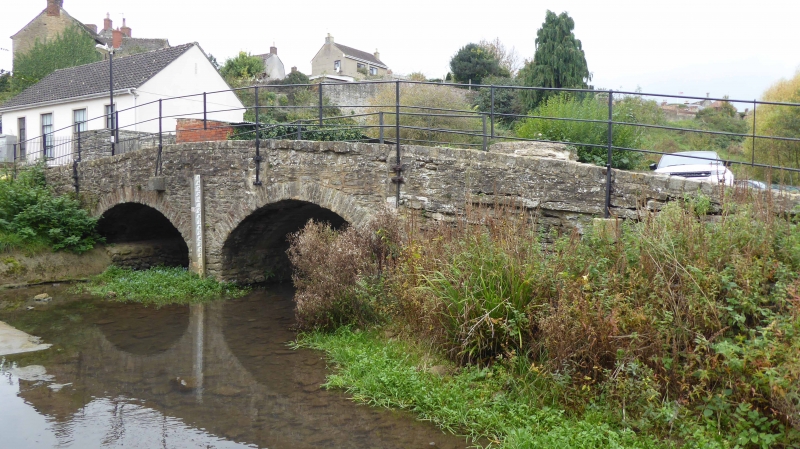
Entry Name: Baskerville Bridge
Listing Date: 1 July 1976
Grade: II
Source: Historic England
Source ID: 1269250
English Heritage Legacy ID: 460956
ID on this website: 101269250
Location: Malmesbury, Wiltshire, SN16
County: Wiltshire
Civil Parish: Malmesbury
Built-Up Area: Malmesbury
Traditional County: Wiltshire
Lieutenancy Area (Ceremonial County): Wiltshire
Church of England Parish: Malmesbury and Brokenborough
Church of England Diocese: Bristol
Tagged with: Bridge
MALMESBURY
ST9387 ST JOHN'S STREET
758-1/2/309 Baskerville Bridge
01/07/76
GV II
Former packhorse bridge. Probably C18 incorporating earlier
abutments. Limestone rubble. 2 raised segmental arches with
cutwater between on upstream side. Earlier abutments, and low
walls. C19 stanchion supports and iron railings.
Listing NGR: ST9354387056
External links are from the relevant listing authority and, where applicable, Wikidata. Wikidata IDs may be related buildings as well as this specific building. If you want to add or update a link, you will need to do so by editing the Wikidata entry.


Other nearby listed buildings
