Approximate Location Map
Large Map »
Latitude: 51.5837 / 51°35'1"N
Longitude: -2.0974 / 2°5'50"W
OS Eastings: 393345
OS Northings: 187211
OS Grid: ST933872
Mapcode National: GBR 2QZ.QJW
Mapcode Global: VH95S.LGJ8
Plus Code: 9C3VHWM3+F2
Entry Name: 5, Oxford Street
Listing Date: 1 July 1976
Grade: II
Source: Historic England
Source ID: 1269302
English Heritage Legacy ID: 460924
ID on this website: 101269302
Location: Malmesbury, Wiltshire, SN16
County: Wiltshire
Civil Parish: Malmesbury
Built-Up Area: Malmesbury
Traditional County: Wiltshire
Lieutenancy Area (Ceremonial County): Wiltshire
Church of England Parish: Malmesbury and Brokenborough
Church of England Diocese: Bristol
Tagged with: Building
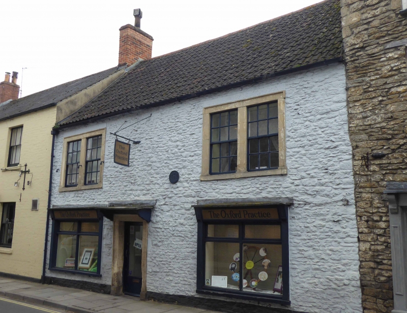
MALMESBURY
ST9387 OXFORD STREET
758-1/4/265 (South side)
01/07/76 No.5
GV II
House. Early C17, early C18 front range. Limestone rubble with
limestone dressings, formerly limewashed, brick right-hand
gable and rear and left-hand lateral stacks, with a pantile
roof to the front and rear cross-gabled range wing with stone
slates.
PLAN: L-shaped plan with left-hand rear range enclosing a
courtyard open to the W.
EXTERIOR: 2 storeys, cellar and attic; 2-window range. A left
of centre doorway has timber bracketed canopy, moulded ashlar
surround and glazed door, C20 shop fronts each side with
plate-glass, and early C18 paired first-floor 6/6-pane sashes
with ashlar surrounds and thick glazing bars, windowless to
the middle.
Rear range has gabled dormers each side, a blocked 3-light
oak-framed mullion window to the E with cyma mouldings, the W
side to the courtyard has timber lintels, with 3-light
first-floor mullion windows, and altered ground-floor
openings.
INTERIOR: details include in the rear wing a good C17
ground-floor fire surround with moulded 4-centred arch and
stops with 2 raised, chamfered bars; similar arched fire
surround on the first floor above; ground-floor gable C19
brick fireplace with cast-iron range with a right-hand
chamfered jamb; roof to the wing of 3 collar trusses, with an
extended collar truss between the dormers, and trenched
purlins; C18 brick fireplace in end gable with bread oven bay
to the left; splayed window reveals.
The cellar has a simple fireplace to the lateral stack and a
flagged floor; across the N end level with the back of the
front range is a canted wall.
HISTORICAL NOTE: the wing may formerly have had a gable to
street.
Listing NGR: ST9334887207
External links are from the relevant listing authority and, where applicable, Wikidata. Wikidata IDs may be related buildings as well as this specific building. If you want to add or update a link, you will need to do so by editing the Wikidata entry.


Other nearby listed buildings
