Approximate Location Map
Large Map »
Latitude: 51.5811 / 51°34'52"N
Longitude: -2.097 / 2°5'49"W
OS Eastings: 393375
OS Northings: 186925
OS Grid: ST933869
Mapcode National: GBR 2QZ.YF4
Mapcode Global: VH95S.LJR7
Plus Code: 9C3VHWJ3+F6
Entry Name: 2, 8 and 10, Kings Wall
Listing Date: 18 January 1949
Grade: II
Source: Historic England
Source ID: 1269309
English Heritage Legacy ID: 460889
ID on this website: 101269309
Location: Malmesbury, Wiltshire, SN16
County: Wiltshire
Civil Parish: Malmesbury
Built-Up Area: Malmesbury
Traditional County: Wiltshire
Lieutenancy Area (Ceremonial County): Wiltshire
Church of England Parish: Malmesbury and Brokenborough
Church of England Diocese: Bristol
Tagged with: Building
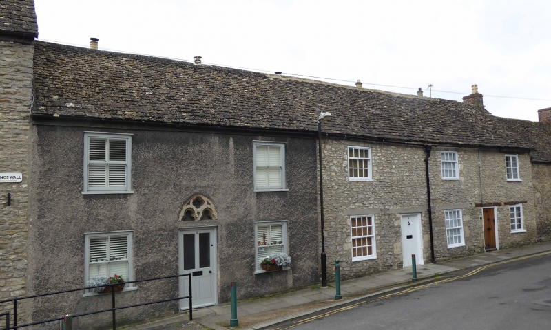
MALMESBURY
ST9386 KINGS WALL
758-1/3/231 (South side)
18/01/49 Nos.2, 8 AND 10
GV II
Terrace of 5, now 3 houses. Mid C18. Limestone rubble, No.2
roughcast, others formerly limewashed, with rubble rear
external lateral stacks and a stone slate roof.
PLAN: single-room plan with rear outshuts, formerly with
through-passages and side entrances between pairs.
EXTERIOR: each 2 storeys; formerly 1-window range, now Nos 2
and 8 are 2-window range. No.2 is symmetrical with a half
glazed door beneath a re-used C13 plate tracery window head
with 2 trefoil arches and centre quatrefoil, and 2/2-pane
horned sashes in exposed boxes; No.8 is symmetrical with a C20
boarded door, rendered lintels, and early C19 8/8-pane
ground-floor and 4/8-pane first-floor sashes; No.10 has timber
lintels to a left-hand boarded door and C19 casements with 4
horizontal bars each. Openings have irregular re-used ashlar
jambs.
Rear has 5 external stacks with offsets and water tables at
eaves level, C18 brick flues, the centre and right of centre
pair linked beneath the water tables; a first-floor casement
to No.8, and ground-floor outshuts.
INTERIOR: details include earlier and reset roof trusses, No.2
has a flagged former through-passage, with a left-hand front
winder stair with stair door. An interesting planned row, with
reused features including morticed lintels to front.
Listing NGR: ST9338486924
External links are from the relevant listing authority and, where applicable, Wikidata. Wikidata IDs may be related buildings as well as this specific building. If you want to add or update a link, you will need to do so by editing the Wikidata entry.


Other nearby listed buildings
