Approximate Location Map
Large Map »
Latitude: 51.5879 / 51°35'16"N
Longitude: -2.1012 / 2°6'4"W
OS Eastings: 393087
OS Northings: 187679
OS Grid: ST930876
Mapcode National: GBR 2QZ.HKL
Mapcode Global: VH95S.JCK1
Plus Code: 9C3VHVQX+5G
Entry Name: Numbers 103 and 105 and Attached Front Walls and Railings
Listing Date: 1 July 1976
Grade: II
Source: Historic England
Source ID: 1269437
English Heritage Legacy ID: 460765
ID on this website: 101269437
Location: Malmesbury, Wiltshire, SN16
County: Wiltshire
Civil Parish: Malmesbury
Built-Up Area: Malmesbury
Traditional County: Wiltshire
Lieutenancy Area (Ceremonial County): Wiltshire
Church of England Parish: Malmesbury and Brokenborough
Church of England Diocese: Bristol
Tagged with: Building
MALMESBURY
ST9387 GLOUCESTER ROAD
758-1/2/103 (East side)
01/07/76 Nos.103 AND 105
and attached front walls and
railings
GV II
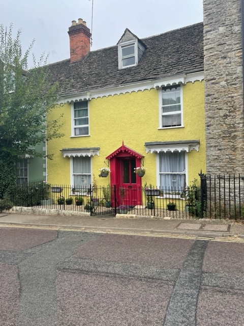
Pair of houses. Early C19, altered mid C19. Rendered limestone
rubble with gable and axial stack, stone slate roof to the
front and pantiles to the rear range.
PLAN: single-depth front and rear ranges separated by axial
passage.
EXTERIOR: 2 storeys and attic; 3:2-window range. Stucco
quoins, with fine fretwork canopy and cornice below eaves and
projecting over windows, missing from ground-floor of No.103,
which has a central doorway with mid C19 pediment canopy and
panelled door and plate-glass sashes; No.105 has a left-hand
doorway with a bracketed timber canopy, narrow overlight and
6-panel door, the top pair glazed, and 6/6-pane sashes; each
with a single gabled dormer with plate-glass sash. Parallel
earlier rear range, with brickwork band beneath eaves marking
raised roof height.
INTERIOR: details of No.105 include an entrance stair hall
with a mid C19 dogleg stair with stick balusters, cast-iron
newel and curtails each side; stone fire surrounds, with axial
passage and steps down to lower rear range.
Listing NGR: ST9308787679
External links are from the relevant listing authority and, where applicable, Wikidata. Wikidata IDs may be related buildings as well as this specific building. If you want to add or update a link, you will need to do so by editing the Wikidata entry.


Other nearby listed buildings
