Approximate Location Map
Large Map »
Latitude: 54.1954 / 54°11'43"N
Longitude: -3.0967 / 3°5'48"W
OS Eastings: 328542
OS Northings: 478288
OS Grid: SD285782
Mapcode National: GBR 6MTX.CV
Mapcode Global: WH725.DTL4
Plus Code: 9C6R5WW3+48
Entry Name: Kings Head Public House
Listing Date: 20 June 1972
Last Amended: 19 April 1996
Grade: II
Source: Historic England
Source ID: 1270186
English Heritage Legacy ID: 460013
ID on this website: 101270186
Location: Ulverston, Westmorland and Furness, Cumbria, LA12
County: Cumbria
District: South Lakeland
Civil Parish: Ulverston
Built-Up Area: Ulverston
Traditional County: Lancashire
Lieutenancy Area (Ceremonial County): Cumbria
Church of England Parish: Ulverston St Mary with Holy Trinity
Church of England Diocese: Carlisle
Tagged with: Pub
ULVERSTON
SD2878 QUEEN STREET
626-1/3/112 (West side)
20/06/72 Nos.12 AND 14
King's Head Public House
(Formerly Listed as:
QUEEN STREET
(West side)
No.12)
(Formerly Listed as:
QUEEN STREET
(West side)
No.14
King's Head)
GV II
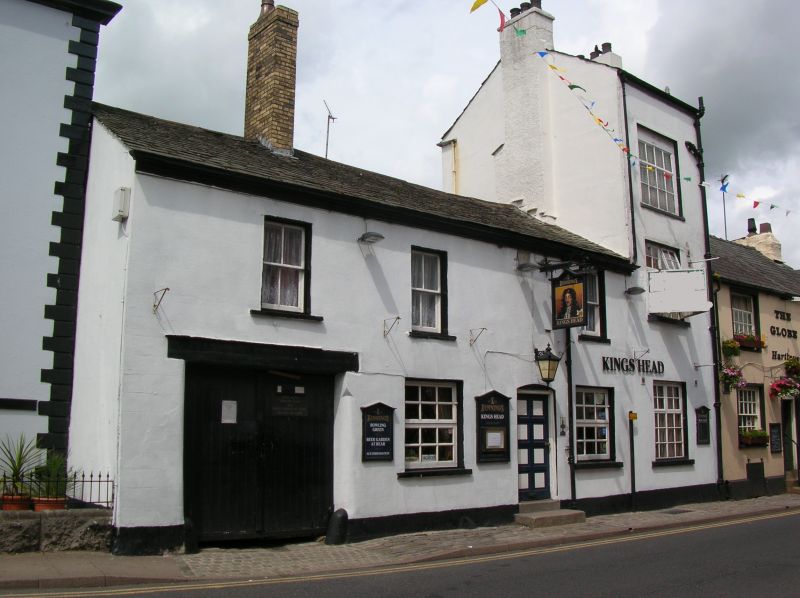
House and public house, now public house. Possibly mid C19
with C18 remains. Painted scored render with slate roof and
brick chimney. Altered 3-room plan.
The main part of building is of 2 storeys and 3 bays. The
windows have plain reveals and projecting painted sills. Those
on the ground floor are now C20 casements with glazing bars.
On the 1st floor they are sashed. A cart entrance in the
left-hand bay has boarded doors and a timber lintel. The
doorway, between the 2nd and 3rd bays, has a segmental head
and is reached by 2 steps. To the right of the 1st bay there
is a tall chimney. At the right is a further bay of 3 tall
storeys, formerly a separate building. It has wide window
openings with plain reveals, projecting sills, and casements
with glazing bars. The ground-floor window opening is a later
C20 alteration. Its gables rise above the adjoining buildings
and have chimneys.
Listing NGR: SD2854278288
External links are from the relevant listing authority and, where applicable, Wikidata. Wikidata IDs may be related buildings as well as this specific building. If you want to add or update a link, you will need to do so by editing the Wikidata entry.


Other nearby listed buildings
