Approximate Location Map
Large Map »
Latitude: 51.3131 / 51°18'47"N
Longitude: 0.1892 / 0°11'21"E
OS Eastings: 552669
OS Northings: 159382
OS Grid: TQ526593
Mapcode National: GBR T3.4CG
Mapcode Global: VHHPL.78C7
Plus Code: 9F32857Q+6M
Entry Name: Forge House Tea Rooms
Listing Date: 15 November 1973
Grade: II
Source: Historic England
Source ID: 1273149
English Heritage Legacy ID: 446070
ID on this website: 101273149
Location: Otford, Sevenoaks, Kent, TN14
County: Kent
District: Sevenoaks
Civil Parish: Otford
Built-Up Area: Otford
Traditional County: Kent
Lieutenancy Area (Ceremonial County): Kent
Church of England Parish: Otford St Bartholomew
Church of England Diocese: Rochester
Tagged with: Smithy
OTFORD OTFORD
1.
5280
High Street
(North Side)
Nos 30 to 34 (even)
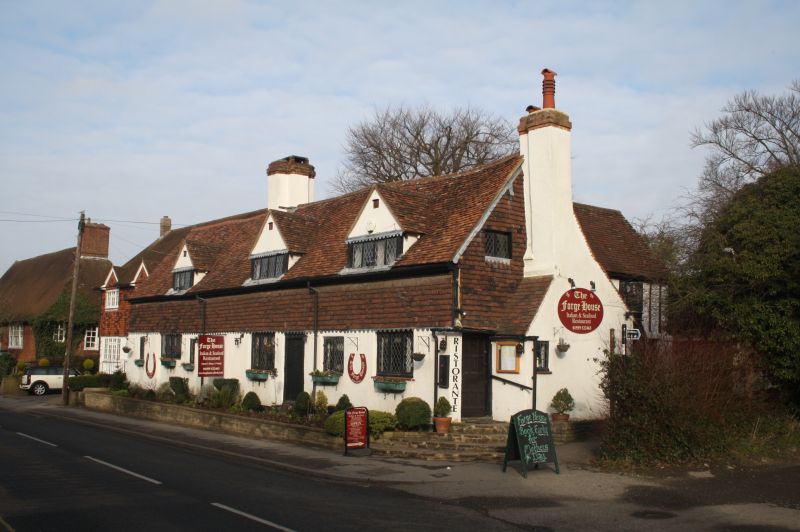
(Forge House Tea Rooms)
TQ 5259 21/762 15.11.73.
II
2.
Long, irregular restored C16 or earlier building. High pitched tiled roof has
ridge stack with rebated angles. 1 storey and 3 half dormers. Tile hung above,
rendered below. Modern leaded casements. Possible hall house.
Listing NGR: TQ5266959381
External links are from the relevant listing authority and, where applicable, Wikidata. Wikidata IDs may be related buildings as well as this specific building. If you want to add or update a link, you will need to do so by editing the Wikidata entry.


Other nearby listed buildings
