Approximate Location Map
Large Map »
Latitude: 51.3689 / 51°22'7"N
Longitude: 0.2136 / 0°12'48"E
OS Eastings: 554181
OS Northings: 165638
OS Grid: TQ541656
Mapcode National: GBR TT.JJ6
Mapcode Global: VHHP6.NV8H
Plus Code: 9F329697+HC
Entry Name: Boyne
Listing Date: 22 October 1982
Grade: II
Source: Historic England
Source ID: 1275537
English Heritage Legacy ID: 411963
ID on this website: 101275537
Location: Eynsford, Sevenoaks, Kent, DA4
County: Kent
District: Sevenoaks
Civil Parish: Eynsford
Built-Up Area: Eynsford
Traditional County: Kent
Lieutenancy Area (Ceremonial County): Kent
Church of England Parish: Eynsford St Martin
Church of England Diocese: Rochester
Tagged with: Building
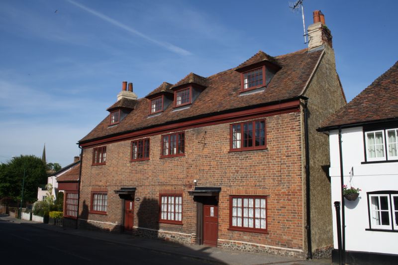
EYNSFORD HIGH STREET
1.
5280 (north-west side)
TQ 5465 12/53 Boyne
II
2.
Early C18. two storeys red brick on flint plinth. Tiled roof sloping to ground
floor at rear. Moulded wooden eaves cornice. Four hipped dormers and 4 casements
Doorcases with flat wooden hoods and moulded architraves.
Listing NGR: TQ5418165638
External links are from the relevant listing authority and, where applicable, Wikidata. Wikidata IDs may be related buildings as well as this specific building. If you want to add or update a link, you will need to do so by editing the Wikidata entry.


Other nearby listed buildings
