Approximate Location Map
Large Map »
Latitude: 51.1237 / 51°7'25"N
Longitude: -0.0064 / 0°0'22"W
OS Eastings: 539613
OS Northings: 137932
OS Grid: TQ396379
Mapcode National: GBR KLY.K60
Mapcode Global: VHGSZ.T0ZX
Plus Code: 9C3X4XFV+FC
Entry Name: 46 46A and 46B, High Street
Listing Date: 28 January 1948
Grade: II
Source: Historic England
Source ID: 1277730
English Heritage Legacy ID: 430564
ID on this website: 101277730
Location: East Grinstead, Mid Sussex, RH19
County: West Sussex
District: Mid Sussex
Civil Parish: East Grinstead
Built-Up Area: East Grinstead
Traditional County: Sussex
Lieutenancy Area (Ceremonial County): West Sussex
Church of England Parish: East Grinstead St Swithun
Church of England Diocese: Chichester
Tagged with: Building
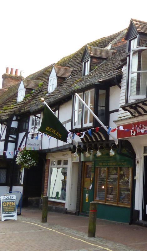
1.
1068 HIGH STREET
(South Side)
No 46.
Nos 46A & 46B
TQ 3937 1/34 28.1.48.
II GV
2.
One overhanging upper storey with exposed timber framing and plaster. C19
oriel on brackets. Horsham slab roof. 2 dormers. Timber framed rear wing.
Nos 34 to 50 (even) form a group.
Listing NGR: TQ3961337932
External links are from the relevant listing authority and, where applicable, Wikidata. Wikidata IDs may be related buildings as well as this specific building. If you want to add or update a link, you will need to do so by editing the Wikidata entry.


Other nearby listed buildings
