Approximate Location Map
Large Map »
Latitude: 51.9911 / 51°59'27"N
Longitude: -2.1613 / 2°9'40"W
OS Eastings: 389017
OS Northings: 232527
OS Grid: SO890325
Mapcode National: GBR 1JR.0DT
Mapcode Global: VH93T.H67Z
Plus Code: 9C3VXRRQ+CF
Entry Name: 59, Church Street
Listing Date: 4 March 1952
Grade: II
Source: Historic England
Source ID: 1282796
English Heritage Legacy ID: 376696
ID on this website: 101282796
Location: Tewkesbury, Gloucestershire, GL20
County: Gloucestershire
District: Tewkesbury
Civil Parish: Tewkesbury
Built-Up Area: Tewkesbury
Traditional County: Gloucestershire
Lieutenancy Area (Ceremonial County): Gloucestershire
Church of England Parish: Tewkesbury St Mary the Virgin (Tewkesbury Abbey)
Church of England Diocese: Gloucester
Tagged with: Building
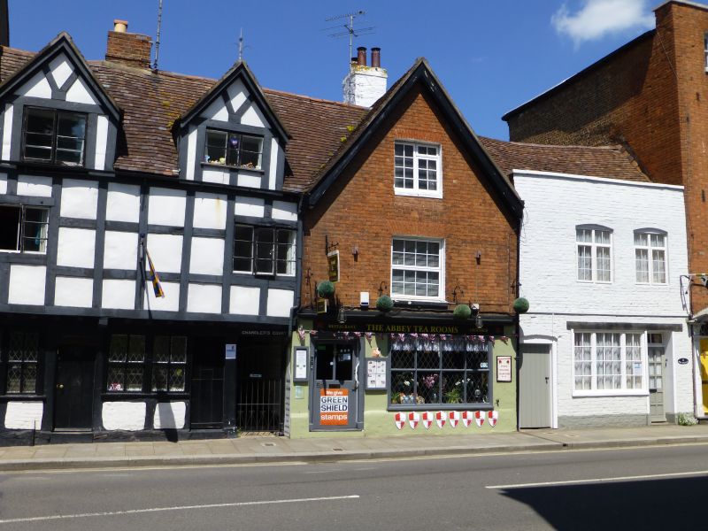
TEWKESBURY
SO8932 CHURCH STREET
859-1/6/116 (North side)
04/03/52 No.59
GV II
House and shop in row. C16 with early C19 front. Set gable to
street, Flemish bond brickwork front on timber-framed body
including cross gable and deep back wing, which originally
formed a back block to the front range.
2 storeys and attic, 1-windowed. 2-light small-pane casement
to stone cill in gable, above C20 replacement, both these to
brick voussoirs. At ground floor, under full-width timber
fascia, an 8-pane fixed shop window, with to left part-glazed
door, all in rendered wall. Brick stack to right of ridge,
behind transverse ridge. In return to Chandlers Court at left
is a narrow gabled dormer unit with C18 lead-paned casement,
and a back wing with large panel timber-framing.
INTERIOR: 2 rooms to front, each with heavy transverse
chamfered beam with stepped run-out stops; that to front room
carried on later figure corbels. Winder stair. Central stack
rebuilt internally.
The back block, although not fully accessible, appears to be a
rare survival of post-medieval urban planning: it is not clear
how it was linked to the front range, although houses of the
"gallery and back-block" type have survived in Devon towns
such as Totnes and Barnstaple.
Listing NGR: SO8901732527
External links are from the relevant listing authority and, where applicable, Wikidata. Wikidata IDs may be related buildings as well as this specific building. If you want to add or update a link, you will need to do so by editing the Wikidata entry.


Other nearby listed buildings
