Approximate Location Map
Large Map »
Latitude: 54.9 / 54°53'59"N
Longitude: -1.3828 / 1°22'58"W
OS Eastings: 439676
OS Northings: 556315
OS Grid: NZ396563
Mapcode National: GBR VCK.QY
Mapcode Global: WHD5C.Q3QF
Plus Code: 9C6WVJX8+XV
Entry Name: St George's House with Attached Steps, Railings and Yard Walls
Listing Date: 10 November 1978
Last Amended: 17 October 1994
Grade: II
Source: Historic England
Source ID: 1292629
English Heritage Legacy ID: 391550
ID on this website: 101292629
Location: Sunderland, Tyne and Wear, SR2
County: Sunderland
Electoral Ward/Division: St Michael's
Parish: Non Civil Parish
Built-Up Area: Sunderland
Traditional County: Durham
Lieutenancy Area (Ceremonial County): Tyne and Wear
Church of England Parish: Millfield St Mark
Church of England Diocese: Durham
Tagged with: Architectural structure
SUNDERLAND
NZ3956SE PARK ROAD
920-1/22/170 (North side)
10/11/78 St George's House with attached
steps, railings and yard walls
(Formerly Listed as:
PARK ROAD
(North side)
St George's House)
GV II
Also known as: St George's Building, Sunderland Polytechnic
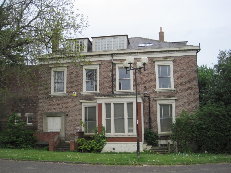
PARK ROAD.
House with steps and railings to door, and yard walls. Used
for teaching accommodation by Sunderland Polytechnic at the
time of listing.
c1855. Garden wall bond brick (5 and 1) with ashlar dressings;
Welsh slate roof. Stone steps and cast-iron railings on S
side. Brick walls and piers with ashlar coping.
EXTERIOR: S and left return elevations have basement and 2
storeys; 4 windows. S elevation: steps up to 3-panel door in
third bay, with plain overlight, in doorcase of engaged,
fluted quasi-Corinthian octagonal columns and dentil cornice
to entablature which breaks forward above columns. Basement
has banded rustication and sashes with glazing bars. Other
sashes, tripartite on ground floor left return, have stone
sills and architraves each with frieze and cornice. Hipped
roof of moderate pitch has C20 dormer. Right return has
set-back C20 addition.
High ashlar-coped walls break forward from right to enclose
yard, and have square brick piers of same height at corners
and forming central entrance to Park Road and side vehicle
entrance on right return of yard. Originally part of St
George's Place, a square which was damaged in WWII.
(Milburn GE and Miller ST: Sunderland River, Town and People:
Sunderland: 1988-: 61,64).
Listing NGR: NZ3967656315
External links are from the relevant listing authority and, where applicable, Wikidata. Wikidata IDs may be related buildings as well as this specific building. If you want to add or update a link, you will need to do so by editing the Wikidata entry.


Other nearby listed buildings
