Approximate Location Map
Large Map »
Latitude: 51.3882 / 51°23'17"N
Longitude: -0.105 / 0°6'17"W
OS Eastings: 531953
OS Northings: 167164
OS Grid: TQ319671
Mapcode National: GBR GW.865
Mapcode Global: VHGRL.4CBN
Plus Code: 9C3X9VQW+72
Entry Name: Wall Enclosing Churchyard of Church of St Saviour
Listing Date: 15 February 1983
Grade: II
Source: Historic England
Source ID: 1294491
English Heritage Legacy ID: 201241
ID on this website: 101294491
Location: St Saviour's Church, Broad Green, Croydon, London, CR0
County: London
District: Croydon
Electoral Ward/Division: Selhurst
Parish: Non Civil Parish
Built-Up Area: Croydon
Traditional County: Surrey
Lieutenancy Area (Ceremonial County): Greater London
Church of England Parish: Croydon Holy Saviour
Church of England Diocese: Southwark
Tagged with: Wall
1.
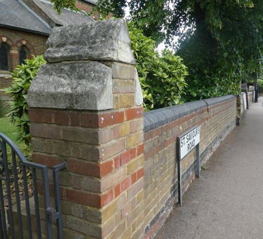
5009 ST SAVIOUR'S ROAD
Wall enclosing churchyard
of Church of St Saviour
2/17A
II GV
2.
Victorian. Yellow and red brick, with standards of brick with stone capping.
Listing NGR: TQ3195367164
External links are from the relevant listing authority and, where applicable, Wikidata. Wikidata IDs may be related buildings as well as this specific building. If you want to add or update a link, you will need to do so by editing the Wikidata entry.


Other nearby listed buildings
