Approximate Location Map
Large Map »
Latitude: 53.9616 / 53°57'41"N
Longitude: -2.017 / 2°1'1"W
OS Eastings: 398980
OS Northings: 451722
OS Grid: SD989517
Mapcode National: GBR GQCM.3M
Mapcode Global: WHB77.ZPPB
Plus Code: 9C5VXX6M+J5
Entry Name: 58, High Street
Listing Date: 2 March 1978
Grade: II
Source: Historic England
Source ID: 1301622
English Heritage Legacy ID: 323462
ID on this website: 101301622
Location: Skipton, North Yorkshire, BD23
County: North Yorkshire
District: Craven
Civil Parish: Skipton
Built-Up Area: Skipton
Traditional County: Yorkshire
Lieutenancy Area (Ceremonial County): North Yorkshire
Tagged with: Building
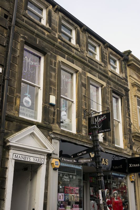
1.
5336 HIGH STREET
(West Side)
No 58
SD 9851 1/72
II GV
2.
C18-19. Ashlar with rusticated quoins, 3 storeys. Ground floor has modern shop
front, and passage entrance to left with triangular pediment. Ovolo moulded
stringcourses. 4 windows on each upper floor, tall and slender on 1st floor,
square on top storey, all with plain reveals.
Listing NGR: SD9897451723
External links are from the relevant listing authority and, where applicable, Wikidata. Wikidata IDs may be related buildings as well as this specific building. If you want to add or update a link, you will need to do so by editing the Wikidata entry.


Other nearby listed buildings
