Approximate Location Map
Large Map »
Latitude: 51.5006 / 51°30'2"N
Longitude: -0.8695 / 0°52'10"W
OS Eastings: 478569
OS Northings: 178566
OS Grid: SU785785
Mapcode National: GBR C56.WJ0
Mapcode Global: VHDWN.WK60
Plus Code: 9C3XG42J+66
Entry Name: Street Wall Between Ousleys and Wargrave House
Listing Date: 18 March 1977
Grade: II
Source: Historic England
Source ID: 1303550
English Heritage Legacy ID: 41361
ID on this website: 101303550
Location: Wargrave, Wokingham, Berkshire, RG10
County: Wokingham
Civil Parish: Wargrave
Built-Up Area: Wargrave
Traditional County: Berkshire
Lieutenancy Area (Ceremonial County): Berkshire
Church of England Parish: Wargrave with Knowl Hill
Church of England Diocese: Oxford
Tagged with: Wall
SU 7878
16/28
18.3.77
WARGRAVE
SCHOOL LANE
(south side)
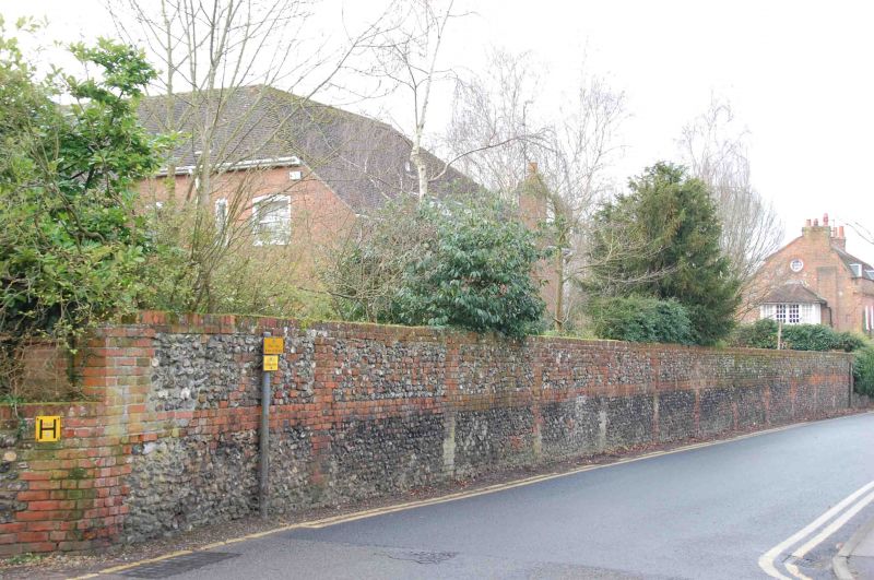
Street wall between Ousleys and Wargrave House
G.V.
II
Wall. Mid C19 About 7 feet high and 100 yards long. Flint and random brick
with brick piers, central band and soldier course to coping. Joined to
Wargrave House by plain brick continuation. Included for group value.
Listing NGR: SU7856978566
External links are from the relevant listing authority and, where applicable, Wikidata. Wikidata IDs may be related buildings as well as this specific building. If you want to add or update a link, you will need to do so by editing the Wikidata entry.


Other nearby listed buildings
