Approximate Location Map
Large Map »
Latitude: 50.7815 / 50°46'53"N
Longitude: -2.9986 / 2°59'55"W
OS Eastings: 329691
OS Northings: 98468
OS Grid: SY296984
Mapcode National: GBR PG.J5Z4
Mapcode Global: FRA 47L0.ZHW
Plus Code: 9C2VQ2J2+JG
Entry Name: Conservative Club and Thomas Whitty House
Listing Date: 11 August 1950
Last Amended: 26 August 1983
Grade: II
Source: Historic England
Source ID: 1309926
English Heritage Legacy ID: 87645
ID on this website: 101309926
Location: Axminster, East Devon, EX13
County: Devon
District: East Devon
Civil Parish: Axminster
Built-Up Area: Axminster
Traditional County: Devon
Lieutenancy Area (Ceremonial County): Devon
Church of England Parish: Axminster St Mary
Church of England Diocese: Exeter
Tagged with: Architectural structure
1/54
In the entry for AXMINSTER SILVER STREET
north east side
Conservative Club
and Autec House
the address shall be amended to read SILVER STREET
north east side
Conservative Club and
Thomas Whitty House
------------------------------------
AXMINSTER SILVER STREET
SY 29 98 (north east side)
1/54
11.8.50 Conservative Club and
GV Autec House (formerly
listed as Law Chambers
and Conservative Club)
II
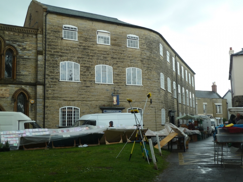
C18 factory building. Once the Axminster Carpet Factory established in 1755 and
closed in 1835. Large dressed stone building. Tarred slate roof with stone coping to
gable ends. Situated on corner site with curved angle. Three storeys. Ten window
range. Segmental arched openings mostly with three-light multi-pane windows with
small central opening lights. All of second floor windows replaced with modern ones.
The first floor six right hand windows are large sashes complete with glazing bars and
in segmental arch openings. Three doorways with large entablatures and Tuscan
pilasters, the centre and right hand retain original flush panel doors. Right hand
segmental arched carriageway.
Listing NGR: SY2969198468
External links are from the relevant listing authority and, where applicable, Wikidata. Wikidata IDs may be related buildings as well as this specific building. If you want to add or update a link, you will need to do so by editing the Wikidata entry.


Other nearby listed buildings
