Approximate Location Map
Large Map »
Latitude: 54.2343 / 54°14'3"N
Longitude: -1.3419 / 1°20'30"W
OS Eastings: 442994
OS Northings: 482263
OS Grid: SE429822
Mapcode National: GBR MM2G.8W
Mapcode Global: WHD8H.CT7T
Plus Code: 9C6W6MM5+P6
Entry Name: Mill Bridge
Listing Date: 15 June 1984
Grade: II
Source: Historic England
Source ID: 1314929
English Heritage Legacy ID: 333278
ID on this website: 101314929
Location: Thirsk, North Yorkshire, YO7
County: North Yorkshire
District: Hambleton
Civil Parish: Thirsk
Built-Up Area: Thirsk
Traditional County: Yorkshire
Lieutenancy Area (Ceremonial County): North Yorkshire
Tagged with: Bridge
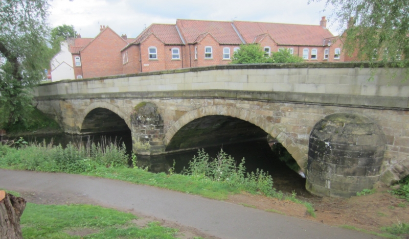
SE 4282 THIRSK BRIDGE STREET
6/39
Mill Bridge
II
Bridge over Cod Beck. 1789. John Carr. Sandstone ashlar. 3 segmental arches.
Cut-waters of semi-circular plan. Band. Coped parapet. Cylindrical domed piers to
the north side. The parapet has been reduced in length on the south side, where some
rebuilding seems to have taken placen to the east. John Carrs' survey on North Riding
Bridges: Book of Bridges 1772-1803. NRCRO. Northallerton.
Listing NGR: SE4299482263
External links are from the relevant listing authority and, where applicable, Wikidata. Wikidata IDs may be related buildings as well as this specific building. If you want to add or update a link, you will need to do so by editing the Wikidata entry.


Other nearby listed buildings
