Approximate Location Map
Large Map »
Latitude: 54.3225 / 54°19'21"N
Longitude: -2.7443 / 2°44'39"W
OS Eastings: 351683
OS Northings: 492138
OS Grid: SD516921
Mapcode National: GBR 9L8G.N8
Mapcode Global: WH82W.TMC4
Plus Code: 9C6V87F4+27
Entry Name: Church of Holy Trinity
Listing Date: 24 April 1951
Grade: I
Source: Historic England
Source ID: 1319009
English Heritage Legacy ID: 75420
ID on this website: 101319009
Location: Holy Trinity Church, Kirkbarrow, Westmorland and Furness, Cumbria, LA9
County: Cumbria
District: South Lakeland
Civil Parish: Kendal
Built-Up Area: Kendal
Traditional County: Westmorland
Lieutenancy Area (Ceremonial County): Cumbria
Church of England Parish: Kendal Holy Trinity
Church of England Diocese: Carlisle
Tagged with: Church of England parish church
This list entry was subject to a Minor Amendment on 5 April 2022 to update text and reformat to current standards
SD 5192 SE
11/79
KENDAL
KIRKLAND (East side)
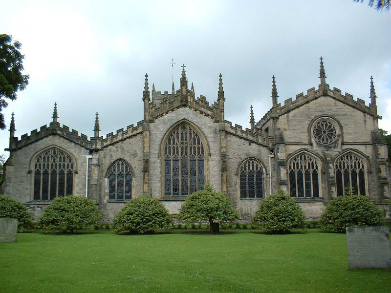
Church of the Holy Trinity
24-4-51
G.V.
I
Parish Church. Established by 1232 (date on indulgence issued for fabric repairs); later medieval additions. Comprehensive C19 restorations in Perpendicular style. Earlier masonry coursed, squared, rubble; later work snecked rubble. Chamfered plinths and stepped buttresses. Lead roofs with gargoyles and pinnacles to castellated parapets. Rectangular plan with double aisles; chancel and west tower incorporated internally.
West porch; 1934 vestry adjoining north side not of interest. Eastern chapels of Bellingham, Parr, and Strickland families contain some fine tombs and memorials. Memorial by Flaxman on north wall; memorial to George Romney on west wall. One of widest medieval parish churches in Britain (103 ft).
For detailed description, history, and plans see: J.F. Curwen "The Parish Church of Kendal" in Transactions of Cumberland & Westmorland Antiquarian & Archaeological Society, Old Series Vol. XVI, pp.157-220; R.C.H.M. (1936), Westmorland, pp.119-122. Forms focus of churchyard group and major feature on riverside.
Listing NGR: SD5168992139
External links are from the relevant listing authority and, where applicable, Wikidata. Wikidata IDs may be related buildings as well as this specific building. If you want to add or update a link, you will need to do so by editing the Wikidata entry.


Other nearby listed buildings
