Approximate Location Map
Large Map »
Latitude: 50.8358 / 50°50'8"N
Longitude: -2.9823 / 2°58'56"W
OS Eastings: 330924
OS Northings: 104485
OS Grid: ST309044
Mapcode National: GBR M6.WN84
Mapcode Global: FRA 46MW.RYP
Plus Code: 9C2VR2P9+83
Entry Name: St Andrews School
Listing Date: 19 October 1984
Grade: II
Source: Historic England
Source ID: 1333539
English Heritage Legacy ID: 87763
ID on this website: 101333539
Location: Chardstock, East Devon, EX13
County: Devon
District: East Devon
Civil Parish: Chardstock
Built-Up Area: Chardstock
Traditional County: Dorset
Lieutenancy Area (Ceremonial County): Devon
Church of England Parish: Chardstock St Andrew
Church of England Diocese: Exeter
Tagged with: School building
ST 3004 CHARDSTOCK CHURCH STREET
19/79 CHARDSTOCK
St Andrews School
GV
II
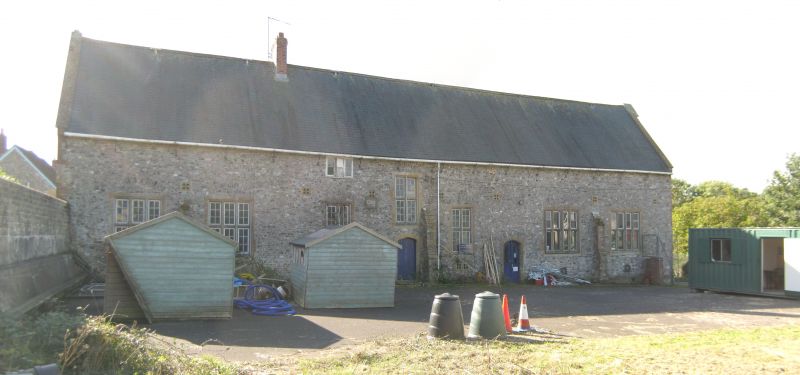
Village school, formerly industrial school. The original school built in 1839
enlarged 1853/6 and 1875. Dated 1853. Formerly St Andrews College and Industrial
Schools founded by Rev C Woodcock.
Knapped flint with freestone dressings. Steeply pitched slate roof with stone
coping and finials to gable ends. E-shaped on plan with parallel ranges at the rear.
Single storey centre with two storeyed projecting porch with shaped gable, four
centred arch doorway with carved spandrels, hood mould and ribbon band above.
To left and right of porch tall rectangular windows in shaped gables. Flanking
wings: right hand school room, one storey and attic with shouldered arch doorway
facing the forecourt. Left hand master's house, two storeys, with four centred arch
porch in the angle and stone oriel in the gable end to road. Left hand (west)
return, gable end of hall has pair of perpendicular windows and cusped rose window
above.
At the rear (north) a long parallel range, two storeys, stone mullion transom
windows, two centred arch doorways and buttresses with set offs.
Further ranges to the north have been demolished.
Reference: Illustrated London News 6 July 1861 page 4.
Listing NGR: ST3092404485
External links are from the relevant listing authority and, where applicable, Wikidata. Wikidata IDs may be related buildings as well as this specific building. If you want to add or update a link, you will need to do so by editing the Wikidata entry.


Other nearby listed buildings
