Approximate Location Map
Large Map »
Latitude: 52.0934 / 52°5'36"N
Longitude: -1.9472 / 1°56'49"W
OS Eastings: 403716
OS Northings: 243899
OS Grid: SP037438
Mapcode National: GBR 3LB.LK7
Mapcode Global: VHB0T.6NG1
Plus Code: 9C4W33V3+94
Entry Name: 29, High Street
Listing Date: 7 May 1952
Last Amended: 24 June 1977
Grade: II
Source: Historic England
Source ID: 1350075
English Heritage Legacy ID: 147433
ID on this website: 101350075
Location: Evesham, Wychavon, Worcestershire, WR11
County: Worcestershire
District: Wychavon
Civil Parish: Evesham
Built-Up Area: Evesham
Traditional County: Worcestershire
Lieutenancy Area (Ceremonial County): Worcestershire
Church of England Parish: Evesham All Saints with St Lawrence
Church of England Diocese: Worcester
Tagged with: Building
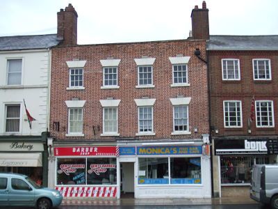
HIGH STREET
1.
5249
(West Side)
No 29
(Formerly listed as
No 36)
SP 0343 NE 1/38 7.5.52.
II GV
2.
C18. Red brick; 5 storeys; 4 sash windows with keyblocks and plain lintels. Late
C19 or early C20 shop front.
Nos 23 to 29 (odd) form a group.
Listing NGR: SP0371143899
External links are from the relevant listing authority and, where applicable, Wikidata. Wikidata IDs may be related buildings as well as this specific building. If you want to add or update a link, you will need to do so by editing the Wikidata entry.


Other nearby listed buildings
