Approximate Location Map
Large Map »
Latitude: 50.9557 / 50°57'20"N
Longitude: -0.5351 / 0°32'6"W
OS Eastings: 502983
OS Northings: 118379
OS Grid: TQ029183
Mapcode National: GBR GJD.3HD
Mapcode Global: FRA 96RL.5BY
Plus Code: 9C2XXF47+7W
Entry Name: Stopham Bridge
Listing Date: 15 March 1955
Grade: I
Source: Historic England
Source ID: 1354033
English Heritage Legacy ID: 298597
ID on this website: 101354033
Location: Stopham, Horsham, West Sussex, RH20
County: West Sussex
District: Horsham
Civil Parish: Pulborough
Traditional County: Sussex
Lieutenancy Area (Ceremonial County): West Sussex
Church of England Parish: Pulborough St Mary
Church of England Diocese: Chichester
PULBOROUGH PETWORTH ROAD
1.
5404
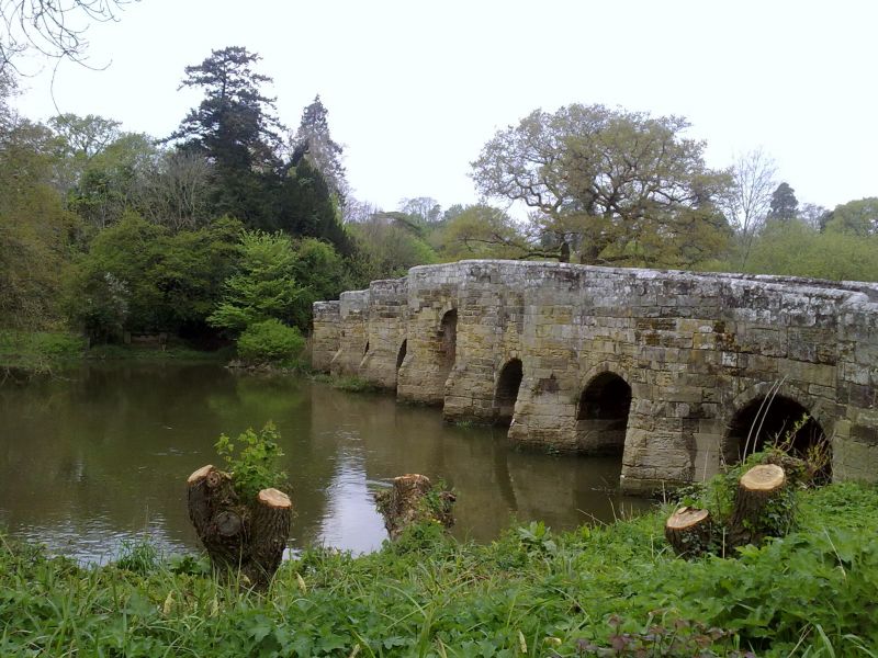
Stopham Birdge
TQ 01 NW 5/784 15.3.55
I
2.
This is partly in former Chanctonbury Rural District and partly in former Petworth
Rural District, as the River Arun, which it spans, is the boundary between them.
There is considerable diversity of opinion about the age of this bridge. T W Horsfield's
History of Sussex says that it was built in 1309. A A Evans in an article in the
Sussex County Magazine in 1936 (Vol 10) gives the date as 1423. E Jervoise's "Ancient
Bridges of the South of England" says that the original bridge was built in 1347
and that the present structure is a replacement dating from the C16. The correct
date is probably 1422-3. One span was destroyed in the Civil War and replaced by
a "drawbridge". This was fenced in 1650. The centre arch was raised in 1822 and
has this date on it. It is built of ironstone and consists of a high segmental
arch in the centre and 2 lower round-headed ones on each side. There are blunt
cutwaters between the arches. These are continued above the water level on the
south side as half hexagonal buttresses and form recesses of this shape for pedestrians
on the Bridge. On the north side the cutwaters are continued the whole height of
the bridge as cutwaters and form triangular recesses on the Bridge. The Bridge
was badly damaged by Army lorries during the war but has been repaired since.
A.M.
Listing NGR: TQ0298318379
External links are from the relevant listing authority and, where applicable, Wikidata. Wikidata IDs may be related buildings as well as this specific building. If you want to add or update a link, you will need to do so by editing the Wikidata entry.


Other nearby listed buildings
