Approximate Location Map
Large Map »
Latitude: 51.7741 / 51°46'26"N
Longitude: -1.6152 / 1°36'54"W
OS Eastings: 426649
OS Northings: 208454
OS Grid: SP266084
Mapcode National: GBR 5T9.LH2
Mapcode Global: VHBZZ.YNHT
Plus Code: 9C3WQ9FM+MW
Entry Name: Elm House
Listing Date: 12 September 1955
Last Amended: 1 March 1990
Grade: II
Source: Historic England
Source ID: 1357131
English Heritage Legacy ID: 422344
ID on this website: 101357131
Location: Shilton, West Oxfordshire, OX18
County: Oxfordshire
District: West Oxfordshire
Civil Parish: Shilton
Built-Up Area: Shilton
Traditional County: Oxfordshire
Lieutenancy Area (Ceremonial County): Oxfordshire
Church of England Parish: Shilton
Church of England Diocese: Oxford
Tagged with: House
SHILTON CHURCH LANE
SP20NE Elm House (previously
4/294 listed as Elm Farm-
12.9.55 house).
GV II
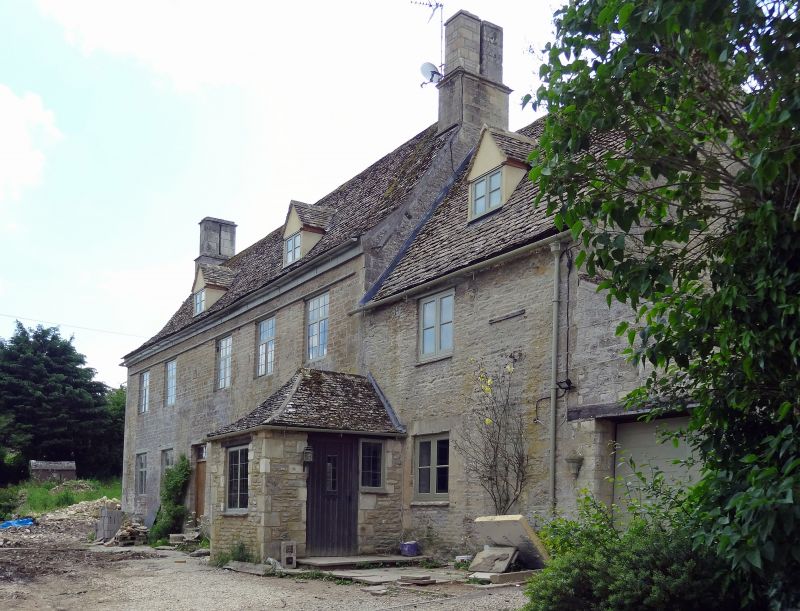
Former Farm House. Dated 1683. Coursed rubble and ashlar quoins on
chamfered plinth, Cotswold stone roof. Square paired end chimneys, to
east retaining joint capping. 2 storeys on basement, gable - lit attic.
2:3 windows, cross mullion wooden casements with chamfered wooden lintels
on ground floor and continuous wooden string lintel over 1st floor. Two
2-light stone mullion windows to basement or cellar (left). Roughly
central ledged door with date in raised letters in panel above. 1-bay
extension to right, chimney dated 1684 - here the ground floor window and
door have stone flat arches. Good interior. Well staircase with ball-
topped newels (2 retain turned underside) and fattish turned balusters on
moulded string. In ground floor east room a good stone Tudor-arch fire-
place with cornice; west room has cambered wooden lintel to fireplace with
cut firearm brackets over, and a wide stop chamfered spine beam. Diamond-
stop-chamfers to door-surrounds. The east room has a plaster design above
the fireplace. A little bit of carving occurs on a quoin to right of main
block.
Listing NGR: SP2664908454
External links are from the relevant listing authority and, where applicable, Wikidata. Wikidata IDs may be related buildings as well as this specific building. If you want to add or update a link, you will need to do so by editing the Wikidata entry.


Other nearby listed buildings
