Approximate Location Map
Large Map »
Latitude: 51.2628 / 51°15'46"N
Longitude: 0.3035 / 0°18'12"E
OS Eastings: 560814
OS Northings: 154039
OS Grid: TQ608540
Mapcode National: GBR MN8.RKG
Mapcode Global: VHHPV.6JT8
Plus Code: 9F327873+4C
Entry Name: Dux Farmhouse
Listing Date: 3 May 1984
Grade: II
Source: Historic England
Source ID: 1362060
English Heritage Legacy ID: 357336
ID on this website: 101362060
Location: Plaxtol, Tonbridge and Malling, Kent, TN15
County: Kent
District: Tonbridge and Malling
Civil Parish: Plaxtol
Traditional County: Kent
Lieutenancy Area (Ceremonial County): Kent
Church of England Parish: Plaxtol
Church of England Diocese: Rochester
Tagged with: Farmhouse
TQ 65 SW PLAXTOL DUX LANE
4/7 (north side)
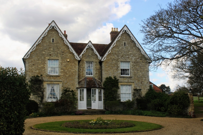
Dux Farmhouse
GV
II
Farmhouse. Mid C19 front to C17 red brick and tile-hung wing to rear. Coursed rubble
stone. Two return-gables to front with smaller gable between. Decorated
barge-boards. Plain tiled roof. Two storeys and attic; 3 windows, glazing bar
sashes. Dripstones over outer ground floor windows. Central glazed splayed
weatherporch with panelled door.
Listing NGR: TQ6099254096
External links are from the relevant listing authority and, where applicable, Wikidata. Wikidata IDs may be related buildings as well as this specific building. If you want to add or update a link, you will need to do so by editing the Wikidata entry.


Other nearby listed buildings
