Approximate Location Map
Large Map »
Latitude: 51.6919 / 51°41'30"N
Longitude: -1.6462 / 1°38'46"W
OS Eastings: 424549
OS Northings: 199300
OS Grid: SU245993
Mapcode National: GBR 5V6.YD6
Mapcode Global: VHC0C.FQ1V
Plus Code: 9C3WM9R3+QG
Entry Name: Barn Approximately 15 Metres South West of Bradshaws Farmhouse
Listing Date: 12 September 1955
Last Amended: 30 March 1989
Grade: II
Source: Historic England
Source ID: 1367746
English Heritage Legacy ID: 253813
ID on this website: 101367746
Location: Kelmscott, West Oxfordshire, GL7
County: Oxfordshire
District: West Oxfordshire
Civil Parish: Kelmscott
Traditional County: Oxfordshire
Lieutenancy Area (Ceremonial County): Oxfordshire
Church of England Parish: Broadwell with Kelmscott
Church of England Diocese: Oxford
Tagged with: Barn
KELMSCOTT
SU2499-2599
10/61 Barn approx. 15m SW of
Bradshaws Farmhouse
12.9.55 (Formerly listed as part of
Bradshaws Farmhouse and 3
barns)
GV II
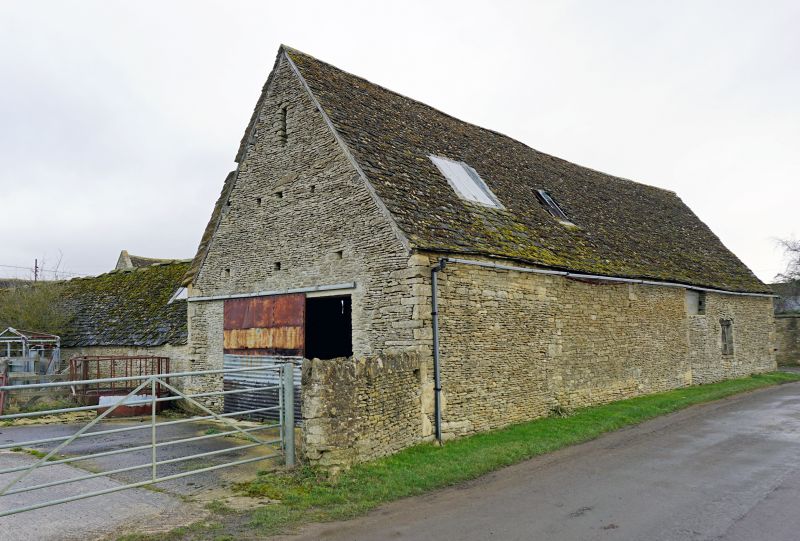
Barn. Late C17 extended mid-C18 with minor later alterations. Roughly coursed
limestone rubble; stone slate roof. Original 3-bay barn with cart entrance added
and extended to left mid-C18. C17 part has gabled cart entrance (weatherboarded
to gable) to right of centre with plank door immediately to left. C18 extension
to left (straight joint) has steeply pitched gable to far right with plank door
breaking eaves approached by external lateral steps; stable door to left on
ground floor. Dripmould to left gable end. Rear (road side) has infilled doorway
with casement inserted to left of centre in.C18 addition and infilled opposing
entrance to cart entrance to C17 part. Interior. C17 part has double-purlin
collar and tie beam roof in 3 bays; C18 addition has chamfered spine and cross
beams to ground floor; double-purl in roof to loft with central collar and tie
beam truss.
[2356]
Listing NGR: SU2454999300
External links are from the relevant listing authority and, where applicable, Wikidata. Wikidata IDs may be related buildings as well as this specific building. If you want to add or update a link, you will need to do so by editing the Wikidata entry.


Other nearby listed buildings
