Approximate Location Map
Large Map »
Latitude: 54.9735 / 54°58'24"N
Longitude: -2.1055 / 2°6'19"W
OS Eastings: 393345
OS Northings: 564324
OS Grid: NY933643
Mapcode National: GBR FBQX.ZY
Mapcode Global: WHB2C.M8L2
Plus Code: 9C6VXVFV+9R
Entry Name: 8 and 9, Holy Island
Listing Date: 18 May 1976
Grade: II
Source: Historic England
Source ID: 1370798
English Heritage Legacy ID: 239157
ID on this website: 101370798
Location: Hexham, Northumberland, NE46
County: Northumberland
Civil Parish: Hexham
Built-Up Area: Hexham
Traditional County: Northumberland
Lieutenancy Area (Ceremonial County): Northumberland
Church of England Parish: Hexham
Church of England Diocese: Newcastle
Tagged with: Building
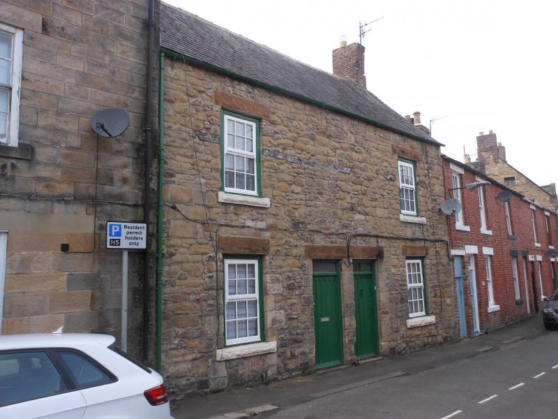
HOLY ISLAND
1.
5334 Nos 8 and 9
NY 9364 1/288
II GV
2.
C18. 2 storeys. 2 windows. Rubble with mid C19, rock faced lintels and cills.
Glazing bar sash windows. Paired doorways with arched beaded panels and rectangular
lights above. 2 storey brick annexe to rear.
Nos 8 to 10 (consec) and Nos 12 to 14 (consec) with Nos 1 and 1A Glovers Place, form a
group.
Listing NGR: NY9334564324
External links are from the relevant listing authority and, where applicable, Wikidata. Wikidata IDs may be related buildings as well as this specific building. If you want to add or update a link, you will need to do so by editing the Wikidata entry.


Other nearby listed buildings
