Approximate Location Map
Large Map »
Latitude: 50.9155 / 50°54'55"N
Longitude: -0.4568 / 0°27'24"W
OS Eastings: 508579
OS Northings: 114027
OS Grid: TQ085140
Mapcode National: GBR GJW.KBN
Mapcode Global: FRA 96XP.CW4
Plus Code: 9C2XWG8V+67
Entry Name: The Horsecroft
Listing Date: 5 September 1986
Grade: II
Source: Historic England
Source ID: 1372086
English Heritage Legacy ID: 361790
ID on this website: 101372086
Location: Storrington, Horsham, West Sussex, RH20
County: West Sussex
District: Horsham
Civil Parish: Storrington and Sullington
Built-Up Area: Storrington
Traditional County: Sussex
Lieutenancy Area (Ceremonial County): West Sussex
Church of England Parish: Storrington St Mary
Church of England Diocese: Chichester
Tagged with: Architectural structure
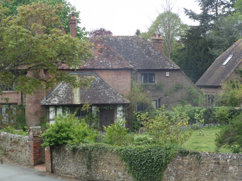
1 STORRINGTON GREYFRIARS LANE (West)
5404 The Horsecroft
TQ 0814-0914
22/566
II GV
2
House. c1900 details in vernacular idiom apparently incorporating a medieval hall
with C14 roof. Green sand stone, brick dressings and returns, old tile roof.
2 storeys, 3 bays, double depth plan with early C20 rear pile. Ground floor has
2 central 2-light and 2 outer 3-light leaded casements, oak framed. Steeply
pitched roof with gablets. Early C20 timber framed and plastered porch at right.
External brick stack at right, in-built stack at left. Interior ground floor
main pile has 3 chambers c1900 in present form with framed partitions and
chamfered beams, reused as cross-beams. First floor has 3 chambers with in situ
framed partition and rear wall with 3 angle posts and wall plate, stack addition
at north now built-in by c1900 rear. Roof (not inspected) has smoke blackened
ridgeless paired close set rafters each with collars halved and pegged, a roof
structure of a medieval pre-1400 type without later altertations and apparently
in situ.
Listing NGR: TQ0857914027
External links are from the relevant listing authority and, where applicable, Wikidata. Wikidata IDs may be related buildings as well as this specific building. If you want to add or update a link, you will need to do so by editing the Wikidata entry.


Other nearby listed buildings
