Approximate Location Map
Large Map »
Latitude: 53.1846 / 53°11'4"N
Longitude: -2.8878 / 2°53'16"W
OS Eastings: 340768
OS Northings: 365645
OS Grid: SJ407656
Mapcode National: GBR 7B.3724
Mapcode Global: WH88F.M61Y
Plus Code: 9C5V54M6+RV
Entry Name: 1-19, HANDBRIDGE (See details for further address information)
Listing Date: 23 July 1998
Last Amended: 26 April 1999
Grade: II
Source: Historic England
Source ID: 1375845
English Heritage Legacy ID: 469824
Also known as: 2–8, Mill Street, 1–19, Handbridge, 1, Queens Park Road
ID on this website: 101375845
Location: Handbridge, Cheshire West and Chester, Cheshire, CH4
County: Cheshire West and Chester
Electoral Ward/Division: Handbridge Park
Parish: Non Civil Parish
Built-Up Area: Chester
Traditional County: Cheshire
Lieutenancy Area (Ceremonial County): Cheshire
Church of England Parish: Chester St Mary without the Walls
Church of England Diocese: Chester
SJ 4065
1932-1/8/170
CHESTER CITY (EM),
HANDBRIDGE (East side),
Nos. 1-19 (Odd)
23.07.1998
GV II
Includes: No.1 QUEEN'S PARK ROAD
Includes: Nos. 2-8 MILL STREET
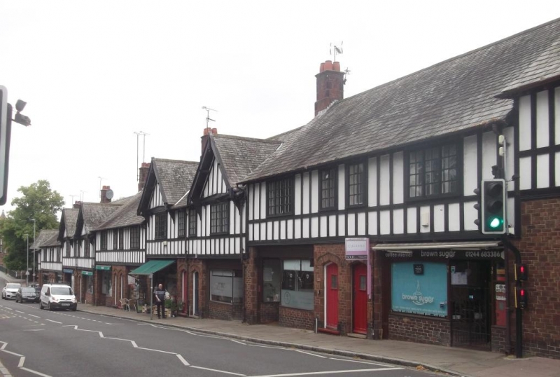
12 shops, a flat over each, one cottage facing corner of Handbridge with Queen's Park Road, right, and 4 cottages to Mill Street, left. 1928-32. By Greenwood, City Engineer. For Chester City Council. Brick shaped and surfaced to simulate red sandstone, timber framing with plaster panels; roof of grey-green and buff slates. Late Vernacular Revival.
EXTERIOR: 2 storeys. The composition comprises a symmetrical range of 4 "stone-brick" cottages facing the Dee across Mill Street, a projecting and jettied gabled shop and flat on the angle with Handbridge, 10 shops with flats above facing handbridge, a projecting and jettied gabled shop and flat at the angle with Queen's Park Road, all with "stone-brick" shops and timber-framed flats; a "stone-brick" cottage towards Queen's Park Road. Oak shopfronts with half-glazed Tudor-arched recessed doors with shaped overlights; paired entrances to flats, each with one step, framed and boarded door on ornate hinges and Tudor archway of "Stone-brick". The upper storey, punctuated with 4 jet tied gables, has rail at sill-level, close studding and casements of 12-pane lights. The roof steps down with slope of street, a plinthed ridge chimney at each step.
INTERIORS: not inspected. The cottages form successful end-stops in a low-key C17 manner to a well-handled composition in a key position adjacent to the Old Dee Bridge.
Included as an excellent example of inter-war municipal town planning, the shops and cottages replaced older shops and condemned dwellings including court-cottages.
Listing NGR: SJ 40768 65645
External links are from the relevant listing authority and, where applicable, Wikidata. Wikidata IDs may be related buildings as well as this specific building. If you want to add or update a link, you will need to do so by editing the Wikidata entry.


Other nearby listed buildings
