Approximate Location Map
Large Map »
Latitude: 50.3364 / 50°20'11"N
Longitude: -4.1266 / 4°7'35"W
OS Eastings: 248755
OS Northings: 50663
OS Grid: SX487506
Mapcode National: GBR NX.X1WC
Mapcode Global: FRA 2874.Q5G
Plus Code: 9C2Q8VPF+H9
Entry Name: Fort Bovisand
Listing Date: 12 November 1999
Grade: II*
Source: Historic England
Source ID: 1379615
English Heritage Legacy ID: 479007
ID on this website: 101379615
Location: South Hams, Devon, PL9
County: Devon
District: South Hams
Civil Parish: Wembury
Traditional County: Devon
Lieutenancy Area (Ceremonial County): Devon
SS 45 SE WEMBURY
237/2/10006 Fort Bovisand
GV II*
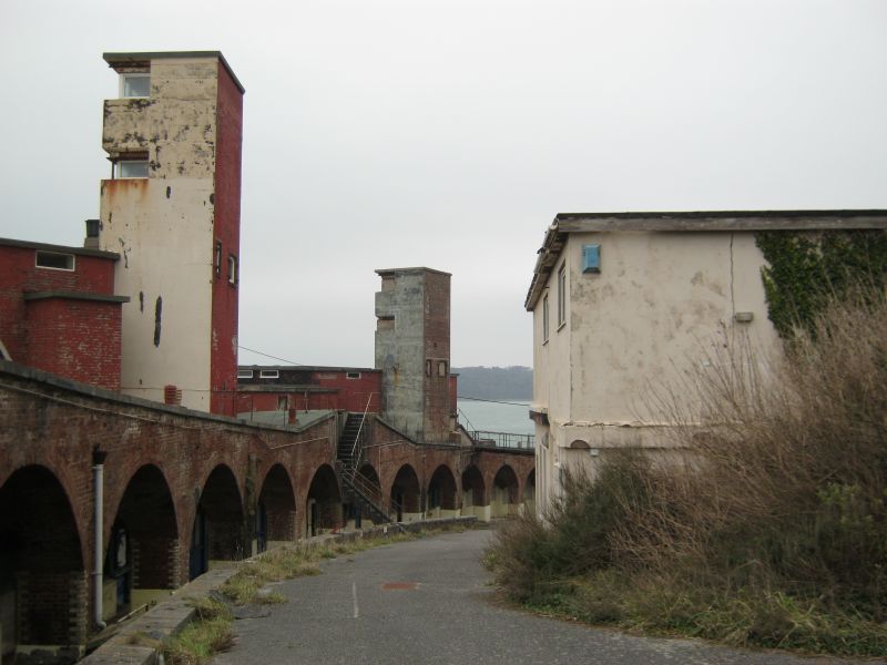
Battery. 1861-69. Granite ashlar with asphalt roofs; hard-core infill and brick interior.
PLAN: 23 casemates set in a curving frontage, looking over Plymouth Sound and sloping downhill from the E to the NW sides, and set above magazine level.
EXTERIOR: each casemate has a segmental-arched rounded surrounds framing an iron shield to its seaward side; these are up to 3 feet thick, consisting of wrought iron plates fastened to an iron concrete or teak core.
The roof was given, in 1885, three pairs of Hotchkiss quick firing (QF) guns for the defence of the minefield between Bovisand and the Breakwater, being replaced by Staddon Point Battery B in 1899: the E pair are complete, 3 others being visible under the structures built in association with the two twin 6-pounder QF guns built to protect the E part of the Sound against motor torpedo boats in 1942. Structures of 1942 comprise flat-roofed shelters of brick and shuttered concrete, reinforced with iron girders, and 3-storey observation tower of similar construction to their rear: the survival of these emplacements with their towers and shelters is unique in the Plymouth area.
INTERIOR: vaulted brick roof to each casemate, which had traversing gun sited to front of barrack accommodation. The front wall has a cartridge lift between each embrasure, and rope mantlets to protect the crews: mantlet bars survive in casemates 12-14 at least, with gun specifications noted on labels above. Dividing walls to rear have fireplaces alternating with shell lifts, some of the pulley loops and davits for the latter having survived. Arched verandah to rear of casemates, originally divided off from latter by glazed timber screens. Two stone spiral stairs provide access to magazines, which alternating shell and cartridge stores each serving two of the guns above and accessed by a passage under the verandah; rooms served by trolley ways and lighting passages. Some original fittings survive, including metal voice pipes, labels to shell lifts and stores and wooden lining to one of the shell and several of the cartridge lifts.
HISTORY: Fort Bovisand, built between 1861 and 1869, was one of two batteries built to protect the entrance to the Sound, at either side of Rennie's breakwater: the other was Picklecombe Fort in Cornwall and, as at Bovisand, the fort built as a result of the 1860 Royal Commission recommendations superseded an earlier battery (Staddon Point Battery). The accepted design of November 1861, a two-tier battery, had been changed by 1864 to a single-tier battery for 23 guns, with the magazines accommodated in the basement below. The original armament of rifled muzzle loaders was removed between 1895 and 1903, and the fort continued to be adapted for new armament until the end of the Second World War. It formed part of the largest body of permanent fortification ever built in Britain, resulting from the renewed fears of French aggression which had led, in 1859, to a Royal Commission being set up in order to review the nation's defences. Most of the 76 forts and batteries under construction or already completed in 1867 were coast batteries, of which Fort Bovisand is one of the best-preserved. Bovisand's design, like the majority of batteries built following the Commission's report in 1860, centred around the provision in a sweeping arc of casemates, chambers accessible from the rear and through which guns fired on a fixed line: with Breakwater Fort and the battery at Drake's Island, it is the best-preserved of the coastal batteries which covered the entrance to the naval port.
A Pye and F Woodward: The Historic Defences of Plymouth (Truro, 1996), pp. 209-14; C Dobinson, Twentieth Century Fortifications in England (Vol. VI, Coast Artillery), Report for English Heritage, Council for British Archaeology, 1999.
Listing NGR: SX4875550663
External links are from the relevant listing authority and, where applicable, Wikidata. Wikidata IDs may be related buildings as well as this specific building. If you want to add or update a link, you will need to do so by editing the Wikidata entry.


Other nearby listed buildings
