Approximate Location Map
Large Map »
Latitude: 52.4153 / 52°24'55"N
Longitude: -2.5585 / 2°33'30"W
OS Eastings: 362107
OS Northings: 279852
OS Grid: SO621798
Mapcode National: GBR BS.NW9Z
Mapcode Global: VH840.LKR7
Plus Code: 9C4VCC8R+4H
Entry Name: Church of St Michael
Listing Date: 12 November 1954
Grade: II*
Source: Historic England
Source ID: 1383760
English Heritage Legacy ID: 484192
ID on this website: 101383760
Location: St Michael's Church, Silvington, Shropshire, DY14
County: Shropshire
Civil Parish: Wheathill
Traditional County: Shropshire
Lieutenancy Area (Ceremonial County): Shropshire
Church of England Parish: Silvington
Church of England Diocese: Hereford
Tagged with: Church building
WHEATHILL
SO67NW SILVINGTON
482-1/7/202 Church of St Michael
12/11/54
GV II*
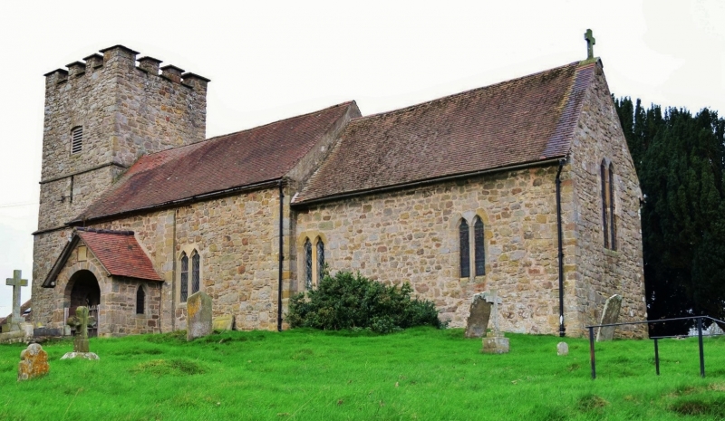
Church. C12 and C14 with C17 additions and alterations, C19
restoration. Rubble stone with ashlar dressings. Plain-tile
roofs.
PLAN: chancel, nave with south porch, and west tower
asymmetrically set against nave. Nave in 2 widths, having been
extended into part of chancel.
EXTERIOR: chancel with restored paired cusped lancets on east
and south sides. Nave north door blocked leaving C12 round
arch exposed. 2 restored paired cusped lancets on both north
and south sides of nave. South doorway has plain tympanum
under bold roll-moulding set in recessed semicircular panel
over tympanum, with scalloped capitals with cable-moulding,
column shafts set in recess on C12 base to west and modified
later base to east. Door is studded, boarded and cross-boarded
with iron strap hinges, bearing date 1679. South porch: tiled
gabled porch with round-arched entrance in stone walls dated
1662. Plain late C12 tower with Transitional west lancet and
restored battlements.
INTERIOR: plastered ceilings and walls. Restored pointed
chancel arch. C17 carved timber panelling around altar. Late
C12 pointed single-stepped tower arch set on hollow chamfered
abaci and debased flat-leafed capitals, below which a diagonal
inset cuts across the stepping of the responds. C12 plain
circular font. Armorial tablet to Edward Mytton d.1683.
Inscription over south porch entrance: "This porch was built
by John Hil, Gent and Ursula his widow 1662".
(The Buildings of England: Pevsner N: Shropshire:
Harmondsworth, Middlesex: 1958-: 289).
Listing NGR: SO6210779852
External links are from the relevant listing authority and, where applicable, Wikidata. Wikidata IDs may be related buildings as well as this specific building. If you want to add or update a link, you will need to do so by editing the Wikidata entry.


Other nearby listed buildings
