Approximate Location Map
Large Map »
Latitude: 50.9027 / 50°54'9"N
Longitude: -3.489 / 3°29'20"W
OS Eastings: 295395
OS Northings: 112529
OS Grid: SS953125
Mapcode National: GBR LH.RKXS
Mapcode Global: FRA 36LQ.6LC
Plus Code: 9C2RWG36+3C
Entry Name: Raised Pavement and Railings in Front of Numbers 1-11 (Odd)
Listing Date: 10 April 2000
Grade: II
Source: Historic England
Source ID: 1384730
English Heritage Legacy ID: 485188
ID on this website: 101384730
Location: Tiverton, Mid Devon, EX16
County: Devon
District: Mid Devon
Civil Parish: Tiverton
Built-Up Area: Tiverton
Traditional County: Devon
Lieutenancy Area (Ceremonial County): Devon
Church of England Parish: Tiverton St Peter
Church of England Diocese: Exeter
Tagged with: Architectural structure
TIVERTON
SS9512 ANGEL HILL, Tiverton
848-1/6/108 (East side)
Raised pavement & railings in front
of Nos 1-11 (odd)
II
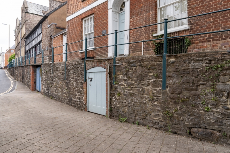
Raised pavement, probably of at least C17 date in origin, but
likely to be late C18 or early C19 in its present form. Stone
rubble base, with concrete top as far north as No.9; blue
brick top in front of No.11 and tarmac beyond, both these
sections with a kerb of flagstones. In its face at 6 openings
of varying styles and dates. At the southern end, in front of
Nos 3 & 5 Angel Hill, are 2 round-headed arches with keystones
the jambs and main parts of the arches being of red brick.
Right-hand arch contains a dried-up well head with
semicircular brick back; keystone is carved with an
inscription, slightly worn and partly covered by an iron pipe,
which seems to be a warning against polluting the well.
Left-hand arch appears to be a cellar entrance with C20 doors.
Third opening from right is another recess with late C19 or
early C20 red brick jambs and segmental arch; believed to have
been used to store sand to stop horses' hooves slipping in icy
weather. Fourth opening is plain with C20 doors, probably
leading to the cellars of No.7 Angel Hill (qv).
Fifth opening, probably early or mid C19, gives access to the
cellars of No.9 Angel Hill (qv); it has red brick jambs (that
to right rebuilt in late C20) and segmental arch of headers.
Sixth opening is a covered driveway into the yard behind
Slee's Almhouses. It has red brick jambs, that to right late
C19 or early C20, that to left rebuilt in late C20; double
plank doors with heavy L-shaped iron hinges.
Along whole pavement a C19 iron railing consisting of circular
moulded uprights supporting 2 rows of horizontal bars.
Listing NGR: SS9539512529
External links are from the relevant listing authority and, where applicable, Wikidata. Wikidata IDs may be related buildings as well as this specific building. If you want to add or update a link, you will need to do so by editing the Wikidata entry.


Other nearby listed buildings
