Approximate Location Map
Large Map »
Latitude: 50.9119 / 50°54'42"N
Longitude: -3.4858 / 3°29'8"W
OS Eastings: 295638
OS Northings: 113546
OS Grid: SS956135
Mapcode National: GBR LJ.QSV8
Mapcode Global: FRA 36LP.MSB
Plus Code: 9C2RWG67+QM
Entry Name: Gates and Gate Piers at Main Entrance to Tiverton Cemetery Including Boundary Wall
Listing Date: 10 April 2000
Grade: II
Source: Historic England
Source ID: 1384873
English Heritage Legacy ID: 485332
ID on this website: 101384873
Location: Tiverton Cemetery, Moorhayes Park, Mid Devon, EX16
County: Devon
District: Mid Devon
Civil Parish: Tiverton
Built-Up Area: Tiverton
Traditional County: Devon
Lieutenancy Area (Ceremonial County): Devon
Church of England Parish: Tiverton St Peter
Church of England Diocese: Exeter
Tagged with: Gate
TIVERTON
SS9513 PARK ROAD, Tiverton
848-1/5/240 (East side)
Gates and gate piers at main
entrance to Tiverton Cemetery incl
boundary wall
GV II
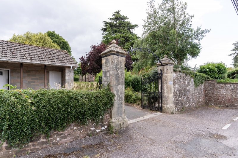
Gates, gate piers at main entrance to Tiverton Cemetery,
including boundary wall extending for about 65m southwards
along Park Road. Probably 1855, or soon after, by GA Boyce of
Tiverton; gates replaced in late C19. Walls are of squared
stone rubble with flat stone coping, except for a short
quadrant section where the coping is of concrete.
Gate piers and a similar pier set into the wall are of stone
ashlar. Gate piers are tall and square in section, with
chamfered and stopped corners; projecting, chamfered plinths,
stepped pyramidial caps with small finials. Double iron gates
with fleurs-de-lys finials to the uprights; matching overthrow
lamp holder, now without the lamp.
To the right is a short, straight stretch of wall with inset
stone tablet inscribed THIS CEMETERY WAS OPENED IN 1855 &
ENLARGED IN 1895. Beyond it the quadrant wall sweeps outward,
finishing in a stretch of wall extending to the southern
boundary of the cemetery.
HISTORY: a letter written by GA Boyce to the Burial Board on
4.5.1858 refers to damage caused to the gates by high winds.
The gates were clearly of wood; Boyce would evidently have
preferred iron, had the money been available.
Listing NGR: SS9563813546
External links are from the relevant listing authority and, where applicable, Wikidata. Wikidata IDs may be related buildings as well as this specific building. If you want to add or update a link, you will need to do so by editing the Wikidata entry.


Other nearby listed buildings
