Approximate Location Map
Large Map »
Latitude: 52.9797 / 52°58'46"N
Longitude: -1.8625 / 1°51'44"W
OS Eastings: 409330
OS Northings: 342487
OS Grid: SK093424
Mapcode National: GBR 37S.3YL
Mapcode Global: WHCF9.CCBK
Plus Code: 9C4WX4HQ+V2
Entry Name: Crumpwood Weir
Listing Date: 27 October 2005
Grade: II
Source: Historic England
Source ID: 1391416
English Heritage Legacy ID: 491903
ID on this website: 101391416
Location: Prestwood, Staffordshire Moorlands, Staffordshire, ST14
County: Staffordshire
District: Staffordshire Moorlands
Civil Parish: Alton
Traditional County: Staffordshire
Lieutenancy Area (Ceremonial County): Staffordshire
Church of England Parish: Alton St Peter
Church of England Diocese: Lichfield
Tagged with: Weir
ALTON
1757/0/10007
27-OCT-05
CHURNET VALLEY
Crumpwood Weir
II
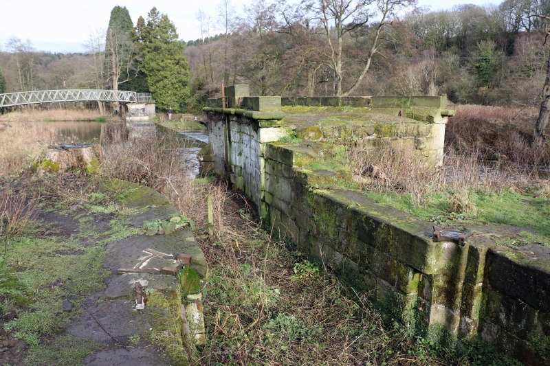
River weir. 1807-1811. Rubble stone brought to course and ashlar. The weir is c. 30 metres in length and has abutments at either end. The weir consists of a vertical drop of c. 1.5 metres and an inclined plane. The abutments are rectangular in shape and battered with a large-scale cyma and roll moulding to the top. The weir was built as part of the Froghall to Uttoxeter Canal which was dug to carry copper and brass from Oakmoor and Alton and coal from Cheadle and Kingsley Moor and also lime stone and flint to the complex of lime kilns at Froghall Wharf. The function of the weir was to allow the canal to cross the Churnet river without needing to build a viaduct. This canal structure is largely intact. It marks the course of the disused canal and has a distinct architectural presence.
The footbridge which springs from the northern abutment and crosses the river is of C20 date and is not included in this item.
Source: Estate Maps of the Trent and Mersey Canal Company, 1816
External links are from the relevant listing authority and, where applicable, Wikidata. Wikidata IDs may be related buildings as well as this specific building. If you want to add or update a link, you will need to do so by editing the Wikidata entry.


Other nearby listed buildings
