Approximate Location Map
Large Map »
Latitude: 54.1885 / 54°11'18"N
Longitude: -1.7576 / 1°45'27"W
OS Eastings: 415912
OS Northings: 476997
OS Grid: SE159769
Mapcode National: GBR JN50.89
Mapcode Global: WHC7B.ZZ6D
Plus Code: 9C6W56QR+CW
Entry Name: Sighting Tower
Listing Date: 31 March 2006
Grade: II
Source: Historic England
Source ID: 1391550
English Heritage Legacy ID: 494885
ID on this website: 101391550
Location: North Yorkshire, HG4
County: North Yorkshire
District: Harrogate
Civil Parish: Ilton-cum-Pott
Traditional County: Yorkshire
Lieutenancy Area (Ceremonial County): North Yorkshire
Tagged with: Tower
1159/0/10006
31-MAR-06
Ilton-cum-Pott
FAIRTHORNE
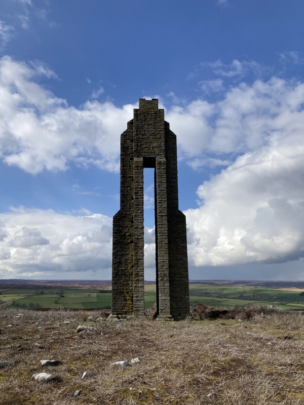
Sighting Tower
II
Survey tower. 1903. Built for the Harrogate Corporation. Hammer dressed stone laid to courses.
The tower is around 14m tall. Two buttressed piers, T shaped in cross section rise some 10m to support the upper portion of the tower. The piers have the heads of their T shapes opposed so that they form a slit 55cm wide and around 10m tall through the tower. The upper portion of the tower is approximately square in section clasped by buttresses rising from the piers.
Supplementary Information
The survey tower was one of three constructed to aid the alignment of the 3 mile long Carlesmoor Aqueduct tunnel. This was constructed to allow water to pass beneath Masham Moor from Roundhill reservoir to supply Harrogate. Permission for the scheme was granted in 1901, the tunnel was completed in 1908 and the scheme was operational in 1911. The other two towers were constructed at SE17407563, on the watershed near High Langwith Cross, and at SE 19487371 just beyond the tunnel portal at Carlesmoor.
Summary of Importance
Because survey towers become redundant once the associated engineering project is completed, they rarely survive nationally. Two separate examples have been listed previously, both chimney-like in design. The survey tower overlooking Roundhill Reservoir is identified as being of special interest as a rare form of structure with an unusually distinctive design.
Listing NGR: SE1591276997
External links are from the relevant listing authority and, where applicable, Wikidata. Wikidata IDs may be related buildings as well as this specific building. If you want to add or update a link, you will need to do so by editing the Wikidata entry.


Other nearby listed buildings
