Approximate Location Map
Large Map »
Latitude: 53.478 / 53°28'40"N
Longitude: -2.2602 / 2°15'36"W
OS Eastings: 382828
OS Northings: 397951
OS Grid: SJ828979
Mapcode National: GBR DFJ.97
Mapcode Global: WHB9G.7VZ2
Plus Code: 9C5VFPHQ+6W
Entry Name: Railway Bridge over River Irwell to Former Liverpool Road Station (That Part in Salford)
Listing Date: 20 February 2007
Grade: I
Source: Historic England
Source ID: 1391927
English Heritage Legacy ID: 502504
ID on this website: 101391927
Location: Salford, M5
County: Salford
Electoral Ward/Division: Ordsall
Built-Up Area: Salford
Traditional County: Lancashire
Lieutenancy Area (Ceremonial County): Greater Manchester
Church of England Parish: Salford St Philip with St Stephen
Church of England Diocese: Manchester
949-1/0/10037
WILBURN STREET,
Railway bridge over River Irwell to former Liverpool Road Station (that part in Salford)
20-FEB-07
GV
I
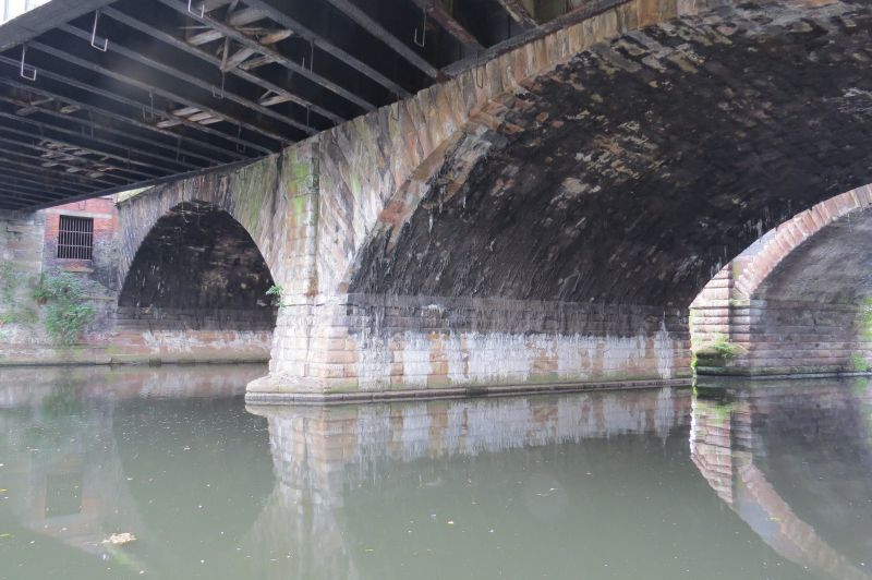
Railway bridge carrying former Liverpool to Manchester railway over River Irwell. 1830 designed by George Stephenson with slight alterations. Cushion-rusticated sandstone ashlar.
DESCRIPTION: Built at a slight angle over the river. Two segmental arches with central pier and cut-water (the east half in City of Manchester). Radiating run-out voussoirs to the arches and pilaster strips to each side of the central pier, and at the east end. Plain dressed cornice and parapet with flat coping.
HISTORY: The railway bridge is an integral component of the former Liverpool Road Station to the east (q.v.) (now The Museum of Science and Industry in Manchester) to which it is linked by an 1830 viaduct and rebuilt 1905 iron bridge over Water Street (q.v.). The station, designed by George Stephenson, was the eastern terminus of the world's first passenger railway line to operate solely using steam locomotives.
The design of the bridge was largely dictated by the Mersey and Irwell Navigation Company, who specified that it should have headroom of at least 29ft with two channels of 63ft to avoid impeding river traffic. The height of the bridge resulted in the level of the rails being well above ground level on the Manchester side, necessitating the construction of a brick viaduct to carry the line, which in turn determined the height of the buildings within Liverpool Road Station. The bridge carried three pairs of railway lines and a roadway to enable the Navigation Company's goods' wagons to cross the river.
SOURCES: Clare Hartwell: Manchester. Pevsner Architectural Guides (2001), 264-268. Display Boards within The Museum of Science and Industry in Manchester.
SUMMARY OF IMPORTANCE
This is an 1830 stone railway bridge crossing the River Irwell. It is of special architectural and historic interest due to its early date, intactness, and design by George Stephenson, the nationally renowned railway engineer. It forms an integral component of Liverpool Road Station, the Manchester terminus for the Liverpool & Manchester Railway Company, which is the world's first surviving passenger railway station (now The Museum of Science and Industry in Manchester), and thus of great historical importance in the development of a national transport infrastructure. As such, the bridge has strong Group Value with the various structures and buildings which formed part of the station. These include the 1830 brick viaduct at its east end and rebuilt 1905 iron bridge over Water Street, the 1830 passenger station, 1830 warehouse, the 1855 railway goods transfer shed (now Power Hall of MSIM), the iron railway bridge abutting its north side together with a second iron bridge over Water Street and colonnaded viaduct leading to the 1880 Lower Byrom Street Warehouse. It also has Group Value with the bridge and viaduct immediately to its south, built by Manchester South Junction & Altrincham Railway Company in 1849, the two bridges converging on the Salford side. Therefore, the bridge is of sufficient special interest in a national context to merit listing at Grade I.
This text is from the original listing, and may not necessarily reflect the current setting of the building.
External links are from the relevant listing authority and, where applicable, Wikidata. Wikidata IDs may be related buildings as well as this specific building. If you want to add or update a link, you will need to do so by editing the Wikidata entry.

Book cover links are generated automatically from the sources. They are not necessarily always correct, as book names at Amazon may not be quite the same as those used referenced in the text.
Source title links go to a search for the specified title at Amazon. Availability of the title is dependent on current publication status. You may also want to check AbeBooks, particularly for older titles.


Other nearby listed buildings
