Approximate Location Map
Large Map »
Latitude: 53.3747 / 53°22'28"N
Longitude: -2.9999 / 2°59'59"W
OS Eastings: 333573
OS Northings: 386893
OS Grid: SJ335868
Mapcode National: GBR 7YHD.BZ
Mapcode Global: WH87D.WFNQ
Plus Code: 9C5V92F2+V2
Entry Name: Rock Ferry Slipway
Listing Date: 4 June 2007
Grade: II
Source: Historic England
Source ID: 1391991
English Heritage Legacy ID: 495810
ID on this website: 101391991
Location: Rock Ferry, Wirral, Merseyside, CH42
County: Wirral
Electoral Ward/Division: Rock Ferry
Parish: Non Civil Parish
Built-Up Area: Birkenhead
Lieutenancy Area (Ceremonial County): Merseyside
Church of England Parish: Rock Ferry St Peter
Church of England Diocese: Chester
Tagged with: Architectural structure
789-1/0/10011 BEDFORD ROAD
04-JUN-07 (East,off)
Rock Ferry Slipway
II
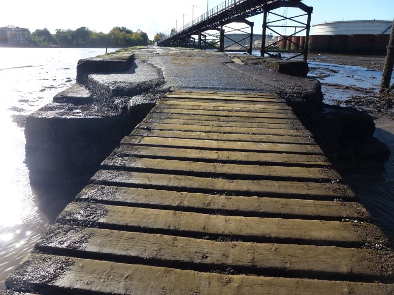
Ferry slipway. Constructed in 1820, with later alterations. By Thomas Morecroft, ferry owner and operator, and developed at a cost of £20,000 to improve facilities on the Rock Ferry to Liverpool ferry service. The slip is surfaced with a combination of sandstone and granite setts and lined either side by large red sandstone blocks, some of which contain iron rings for tying up vessels, together with some timber bullwarks for added protection along the lower part of its length. It measures approximately 230m long and runs from the eastern end of Bedford Road East into the River Mersey and enabled passengers to board the ferry boats at any state of the tide. At the landward end it contains some later modifications including the addition of a kerbed footpath and the remains of a partly demolished brick wall on its south side, and walling and fencing belonging to a redundant oil terminal attached to its north side.
HISTORY: Although ferries across the River Mersey have operated at least since the time of the Domesday Survey a ferry service from Rock Ferry to Liverpool did not commence until the mid-C17. Daniel Defoe is thought to have travelled on this ferry in 1725 during his researches for his book, "A Tour Through The Whole Island Of Great Britain," and gives a graphic description in the book of his disembarkation on the Liverpool shore. The slipway is considered to be the oldest surviving solid structure to be built into the River Mersey. During the 1830's a company was formed to develop Rock Ferry as a residential area and operate a ferry service through lessees. Messrs Thompson and Gough of Eastham became the lessees and owned a fleet of ferry boats operating from Rock Ferry, New Ferry and Eastham to Liverpool. At about this time steam was introduced on the Rock Ferry service. This partnership ended in the 1880's after which the Rock Ferry Company took over operations until 1899 when Birkenhead Corporation took over the running of the service. In that year a new New Ferry, Rock Ferry and Liverpool service opened and a new iron pier with timber decking, floating landing stage, lighthouse and fog bell was constructed alongside the existing slipway at Rock Ferry which subsequently became redundant for ferry services.
SOURCES: Defoe,D. "A Tour Through The Whole Island Of Great Britain." Penguin. 1986. P540. ISBN 0-14-043066-0.
Robinson,K.D. Forgotten Ferries Of Old Lancashire, PP17-19. Unpublished M/s.
Summary:
This early C19th ferry slipway is of special interest because it is considered to be the oldest surviving structure to be built into the River Mersey. It represents the first example of a permanent structure to be constructed specifically for passengers using the Mersey ferries and despite having fallen into disuse with the withdrawal of this particular ferry service it remains intact and survives in good condition. Survival of ferry passenger facilities of this period are very rare nationally and this well-preserved example fully merits listing at Grade II.
External links are from the relevant listing authority and, where applicable, Wikidata. Wikidata IDs may be related buildings as well as this specific building. If you want to add or update a link, you will need to do so by editing the Wikidata entry.


Other nearby listed buildings
