Approximate Location Map
Large Map »
Latitude: 51.6906 / 51°41'26"N
Longitude: 0.4194 / 0°25'9"E
OS Eastings: 567323
OS Northings: 201860
OS Grid: TL673018
Mapcode National: GBR NJJ.YNF
Mapcode Global: VHJK7.7R2W
Plus Code: 9F32MCR9+6P
Entry Name: Milestone 27 Metres South South West of the Spread Eagle Public House
Listing Date: 18 June 2007
Grade: II
Source: Historic England
Source ID: 1392080
English Heritage Legacy ID: 502735
ID on this website: 101392080
Location: Margaretting, Chelmsford, Essex, CM4
County: Essex
District: Chelmsford
Civil Parish: Margaretting
Built-Up Area: Margaretting
Traditional County: Essex
Lieutenancy Area (Ceremonial County): Essex
Church of England Parish: Margaretting St Margaret
Church of England Diocese: Chelmsford
Tagged with: Milestone
719/0/10093
18-JUN-07
MARGARETTING
ROMAN ROAD
Milestone 27m SSW of The Spread Eagle Public House
II
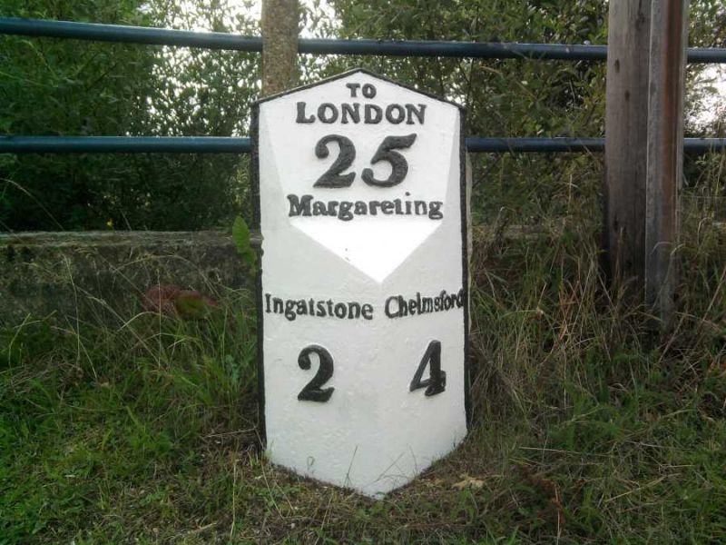
Milestone and cover plate. C18 and C19. Limestone and cast iron. One vertical surface of the cast iron cover plate is embossed with 'Chelmsford 4' and the other with 'Ingatstone 2'. A sloping surface above is embossed with 'To London 25 Margareting'.
HISTORY: This is one in a series of milestones erected in the C18 by the Essex Turnpike Trust to mark the distances along the 'Great Essex Road', which ran from London to Harwich. The design of the cover plate, which was added later, was initiated by James McAdam and adopted by the Trust in 1819 to reduce the frequent cost of re-cutting the inscriptions in the stones.
SOURCES: www.milestonesonline.co.uk; www.milestone-society.co.uk
SUMMARY OF IMPORTANCE: Milestones survive in large numbers as important indicators of road use and to merit listing they must survive in their original position and be largely intact. This is a good example of a milestone erected along the 'Great Essex Road'. It appears to be in its original location and retains its cast iron cover plate.
External links are from the relevant listing authority and, where applicable, Wikidata. Wikidata IDs may be related buildings as well as this specific building. If you want to add or update a link, you will need to do so by editing the Wikidata entry.


Other nearby listed buildings
