Approximate Location Map
Large Map »
Latitude: 51.525 / 51°31'29"N
Longitude: -0.0523 / 0°3'8"W
OS Eastings: 535217
OS Northings: 182470
OS Grid: TQ352824
Mapcode National: GBR J8.PHK
Mapcode Global: VHGQV.1XQV
Plus Code: 9C3XGWFX+X3
Entry Name: Eastern Counties Railway London Viaduct
Listing Date: 4 September 2007
Grade: II
Source: Historic England
Source ID: 1392241
English Heritage Legacy ID: 501023
ID on this website: 101392241
Location: Bethnal Green, Tower Hamlets, London, E2
County: London
District: Tower Hamlets
Electoral Ward/Division: Bethnal Green
Parish: Non Civil Parish
Built-Up Area: Tower Hamlets
Traditional County: Middlesex
Lieutenancy Area (Ceremonial County): Greater London
Church of England Parish: St John on Bethnal Green
Church of England Diocese: London
Tagged with: Viaduct Railway viaduct
788/0/10160 BETWEEN CAMBRIDGE HEATH AND GLOBE ROAD
04-SEP-07 Eastern Counties Railway London Viaduct
II
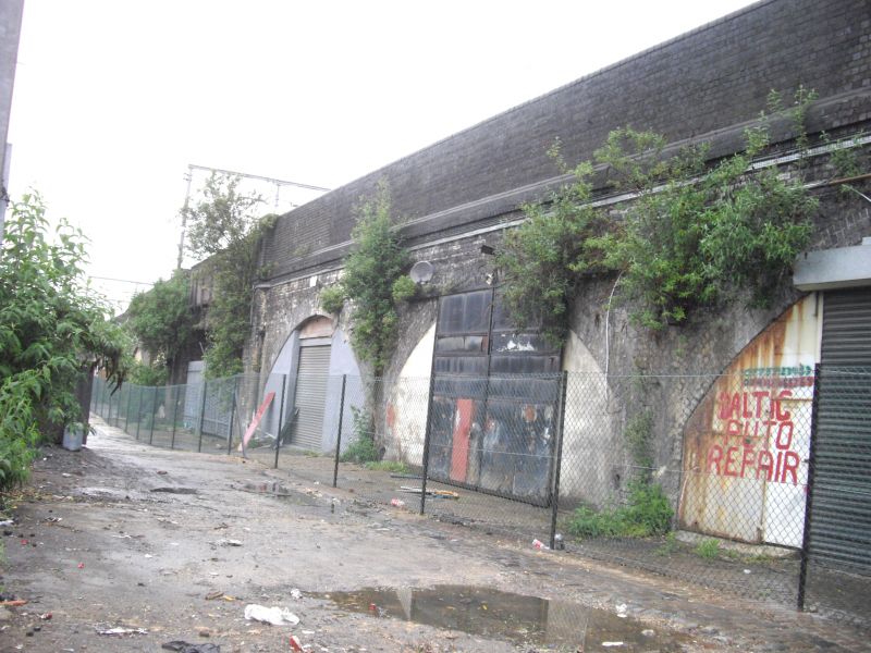
Section of the north side of the Former Eastern Counties Railway Viaduct, from east side of Cambridge Heath Road to the west side of Globe Road. 1838-40, with later alterations. John Braithwaite (1797-1870), engineer.
MATERIALS: Yellow stock brick, with sandstone dressings.
EXTERIOR: This stretch of the viaduct runs for approx. 360 m. in length along the north side of the main railway approach to Liverpool Street. From west to east, this comprises the following sections. The bridge over Cambridge Heath Road is a later 19th century replacement. The section covered by listing starts to the east of this bridge, with a blind arch, with four courses of headers, set between two pylon-formed buttresses. At track level is a projecting plat band of sandstone; above this is a parapet of brick, reconstructed or removed in certain sections. Next, a run of three arches, with another pylon-shaped buttress to the east: like all the arches, they have five bands of brick headers above the openings, which have been in-filled with modern frontages (of no historic interest), and they have been deepened to the rear with the later 19th century widening of the viaduct. Beyond the buttress, another run of eight arches: east of this is another pair of pylon-formed buttresses with a blind arch in the middle. A skew bridge with a masonry surround, consisting of channelled voussoirs, spans Malcolm Street to Braintree Street. This bridge has an impost band of sandstone, and angled courses of brickwork to its underside; it has been widened to the south. To the east of this bridge is another pair of pylon-formed buttresses, flanking a blind arch, followed by a row of three blind arches, in front of which is a granite sett-paved roadway. The skew bridge over Hadleigh Street (now closed) to the east has been replaced in c.1880 with a substantial iron bridge carried on cast iron Tuscan columns, and with blue brick abutments: although of a later date, the bridge is still of interest for its five slanting rows of columns. To the eat of Hadleigh Street is a single blind arch, with a pylon-formed buttress to its left. Beyond is a further row of five now-filled arches, with seven courses of headers above each opening: these are part-concealed by private property abutting them. Towards the eastern end of this row the brick parapet is discontinued. The bridge at the south end of Sceptre Road, now closed off and in private ownership, is flanked on either side by blind arches: it comprises a shallow segmental arch with sandstone voussoirs, over a sandstone impost band. The row of arches continues to the east of this bridge, up to the western side of Globe Road, but is hidden behind houses in Portman Place.
HISTORY: this viaduct carried the first railway to connect London with East Anglia, the Eastern Counties Railway. Established by an Act of 1836, the railway initially connected Romford with Mile End, in June 1839: the line was continued westwards to Shoreditch in June 1840 (renamed Bishopsgate in 1845). The engineer was John Braithwaite (1797-1870), a noted mechanical engineer who was also given responsibility for the construction of the line, which was designed to carry a broad, non-standard gauge of 5 ft-wide track (changed to the standard gauge in 1844). After the slightly earlier London and Greenwich Railway viaduct, of 1836, this is one of the earliest, and longest, examples of a first generation railway structure to survive in Greater London. Following the creation of the Great Eastern Railway in 1862, work began on the construction of Liverpool St Station and the widening of approaches: substantial widening was carried out in this area in 1891. This stretch of viaduct is architecturally the most handsome, with finely tooled masonry bridge openings and balanced rows of arches showing the influence of Neo-classicism. The arcade along Malcolm Street was originally called Railway Place. The viaduct is of great significance as a surviving structure from the first generation of railway building.
SOURCES: J.E. Connor, 'Liverpool Street to Ilford' (Midhurst 1999); G. Goslin, 'John Braithwaite and the Bishopsgate Viaduct' (London Railway Heritage Society 2002).
External links are from the relevant listing authority and, where applicable, Wikidata. Wikidata IDs may be related buildings as well as this specific building. If you want to add or update a link, you will need to do so by editing the Wikidata entry.


Other nearby listed buildings
