Approximate Location Map
Large Map »
Latitude: 51.126 / 51°7'33"N
Longitude: 1.3429 / 1°20'34"E
OS Eastings: 634008
OS Northings: 141614
OS Grid: TR340416
Mapcode National: GBR X30.BBP
Mapcode Global: VHLHC.7Y9Q
Plus Code: 9F3348GV+95
Entry Name: Eastern Arm, Dover Harbour
Listing Date: 16 December 2009
Grade: II
Source: Historic England
Source ID: 1393604
English Heritage Legacy ID: 507155
ID on this website: 101393604
Location: Dover, Kent, CT16
County: Kent
District: Dover
Civil Parish: Dover
Built-Up Area: Dover
Traditional County: Kent
Lieutenancy Area (Ceremonial County): Kent
Tagged with: Architectural structure
DOVER
685/0/10032 Eastern Arm, Dover Harbour
16-DEC-09
GV II
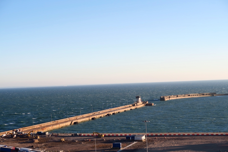
Harbour pier. Completed by 1908. Constructed by the firm of Coode, Son and Mathews as part of the Admiralty Harbour project. The late C20 control tower at the end is not of special interest.
MATERIALS: Constructed of concrete blocks of 26 to 42 tons each, faced above sea level with granite.
PLAN: It is a breakwater 3,300 long projecting from the landward side in a south westerly direction and forming the eastern side of Dover Harbour.
DESCRIPTION: The seaward side is battered and the harbour side has vertical sides. The seaward end is splayed. Towards the end on the harbour side is a flight of stone steps. Also, towards the end, accommodation and magazines were provided for gunners during the First World War to protect the 670 feet long entrance to the harbour between the Eastern Arm and the Southern Breakwater.
HISTORY: It was constructed after 1898 and before 1908 as the Eastern Arm of Admiralty Harbour, which also included the extension to Admiralty Pier and the Southern Breakwater. The Admiralty Harbour was designed to provide a protected anchorage for the naval fleet and increase the protection of the commercial harbour. No structure is shown in this position on the 1898 Ordnance Survey map but it is shown complete on the 1908 sheet. Defences to the three parts of Admiralty Harbour were provided in the final phases of construction and concentrated on the ends of the breakwaters. Anti-aircraft guns were provided in concrete emplacements with searchlights in boom defences and associated accommodation and magazines. During the First World War the harbour provided a haven for the Dover Patrol to keep control of the English Channel. In 1926 it was decided that the harbour had limited military use and the three component parts of Admiralty Harbour were handed over to the Dover Harbour Board for administration as a commercial undertaking. A car ferry began from the Eastern Arm in 1928. During the Second World War Dover Harbour was particularly important in the 1940 Dunkirk evacuation. After 1945 the Navy pulled out and in 1953 a car ferry was started from the Eastern Docks. In 1966 a Hoverport was started here but was moved to the Western Docks in 1978. Currently there is a Car Ferry terminal adjoining.
SOURCES:
R A Otter, Civil Engineering Heritage. Southern England (1994)p247-48
A Saunders and K Smith, Kent's Defence Heritage. Vol 1. KD 107 Dover Harbour Breakwater Defences (2001)
Col. B E Arnold, Conflict Across The Straights (1982)
REASONS FOR DESIGNATION: The Eastern Arm, Admiralty Harbour, is designated at Grade II for the following principal reasons:
* It was designed as the eastern breakwater to a vast artificial harbour called Admiralty Harbour, designed by the firm of Coode, Son and Mathews and built between 1898 and 1909, designed to provide a harbour of refuge for the British fleet.
* This was a huge and impressive engineering feat and the first artifical harbour to be built in the C20.
* It survives little altered apart from the loss of the end lighthouse.
* It is an integral part of the Admiralty Harbour scheme which also includes Grade II Admiralty Pier and the Southern Breakwater.
* It has historical interest for its wartime role during both world wars; in the First World War as a haven for battleships and submarines protecting the Channel and in the Second World War for its part in the Dunkirk evacuation.
The Eastern Arm, Dover Harbour is designated at Grade II for the following principal reasons:
* It was designed as the eastern breakwater to a vast artificial harbour called Admiralty Harbour designed by the firm of Coode, Son and Mathews and built between 1898 and 1908, designed to provide a harbour of refuge for the British Fleet.
* This was a huge and impressive engineering project and the first artificial harbour to be built in the C20.
* The Eastern Arm survives little altered, apart from the loss of the end lighthouse.
* It is an integral part of the Admiralty Harbour, along with Admiralty Pier and the Southern Breakwater.
* It has historical interest for its wartime role during both world wars; in the First World War as a haven for battleships and submarines protecting the Channel and in the Second World War for its part in the Dunkirk evacuation.
External links are from the relevant listing authority and, where applicable, Wikidata. Wikidata IDs may be related buildings as well as this specific building. If you want to add or update a link, you will need to do so by editing the Wikidata entry.


Other nearby listed buildings
